
Kernel Density Estimation for Seismic Hazard Mapping in Indonesia: Influence of Kernel Function, Bandwidth Size, and Grid Resolution
DOI:
https://doi.org/10.48048/tis.2025.10064Keywords:
Kernel Density Estimation, Earthquake Mapping, Earthquake Prediction, Hotspot Analysis, Kernel Density Estimation, Seismic Hazard Mapping, Hot Spot Analysis, Earthquake Density Distribution, Grid-Based Spatial Analysis, Kernel Function Evaluation, Bandwidth SensitivityAbstract
Identifying earthquake-prone areas is critical for disaster mitigation to reduce casualties and economic losses. This study applies Kernel Density Estimation (KDE) to analyze and rank earthquake-prone regions in the context of seismic hazard mapping, focusing on variations in kernel functions, bandwidth sizes, and grid resolutions. The Indonesian Earthquake Catalog (1964 - 2023) is used as a case study. The results indicate that different kernel functions have unique strengths. The Epanechnikov kernel provides an even density distribution, particularly in low and medium categories, while the Gaussian kernel captures high concentrations effectively, especially in high and extreme categories. The Biweight kernel performs well in medium and high categories but less effectively identifies extreme density concentrations. Grid resolution also significantly impacts results; smaller grids 0.25o 0.25o reveal detailed density patterns but may overemphasize localized concentrations, whereas larger grids 5o 5o are suited for macro-scale analyses but can obscure finer variations. Bandwidth size selection significantly affects density estimates. Smaller bandwidths (0.1) spread density widely, resulting in many grids in the low category but fewer in the medium, high, and extreme categories. Medium bandwidths (0.3) increase the proportion of medium and high categories, while larger bandwidths (0.5) produce the highest proportion of grids in the medium category, though extreme values remain limited. These variations demonstrate how bandwidth choices influence the balance between localized detail and broader distribution patterns. KDE effectively identifies earthquake-prone areas with varying densities and cluster significance, providing essential insights for disaster mitigation and spatial planning. The Gaussian kernel, 0.5 bandwidth, and 1o 1o grid combination yields the most significant results in mapping earthquake risk. However, the study has some limitations, including sensitivity to dataset completeness, parameter selection, and the smoothing effect of KDE that may underrepresent low-frequency events, particularly in sparse-data regions, which may introduce uncertainties in density estimations. Future studies could explore adaptive bandwidth selection and refined spatial resolution to enhance the robustness of KDE-based earthquake hazard mapping.
HIGHLIGHTS
This research investigates using Kernel Density Estimation (KDE) to map earthquake-prone areas in Indonesia. The primary findings include identifying and rating seismic risk zones using KDE, a statistical method for spatially representing earthquake density. KDE allows for a more detailed visualization of earthquake-prone zones by analyzing differences in kernel functions, bandwidth size, and grid resolution. This method permits seismic risk assessment using historical earthquake data, providing valuable insights for disaster mitigation and spatial design.
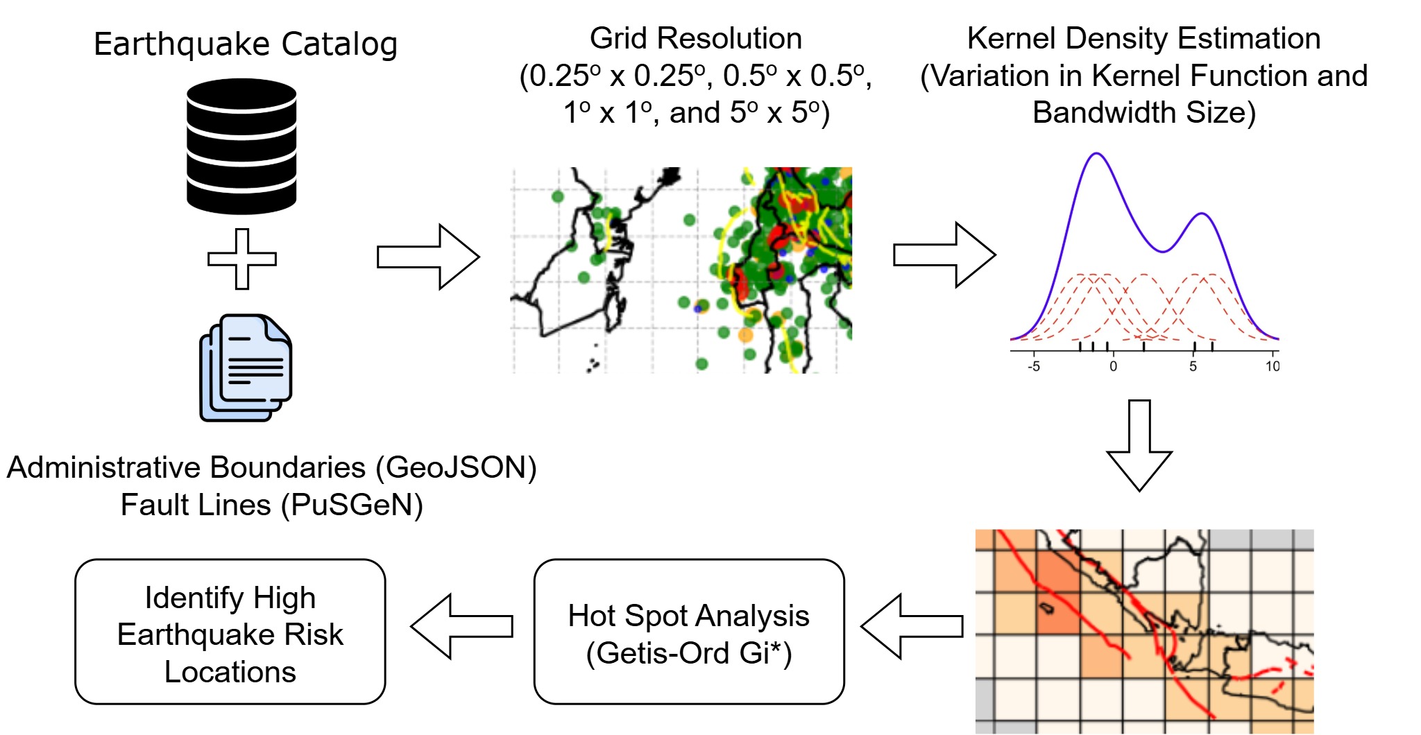
GRAPHICAL ABSTRACT
Downloads
References
WL Hakim and LC Wook. A review on remote sensing and GIS applications to monitor natural disasters in Indonesia. Korean Journal of Remote Sensing 2020; 36(6), 1303-1322.
TH Siagian, P Purhadi, S Suhartono and H Ritonga. Social vulnerability to natural hazards in Indonesia: Driving factors and policy implications. Natural Hazards 2014; 70(2), 1603-1617.
MN Malawani, F Lavigne, C Gomez, BW Mutaqin and DS Hadmoko. Review of local and global impacts of volcanic eruptions and disaster management practices: The Indonesian example. Geosciences 2021; 11(3), 109.
D Kurniati, MZ Fauzi, R Ripangi, A Falegas and I Indria. Klasterisasi daerah rawan gempa bumi di Indonesia menggunakan algoritma k-medoids. MALCOM: Indonesian Journal of Machine Learning and Computer Science 2021; 1(1), 47-57.
W Achmad. The effectiveness of earthquake disaster management policy in Indonesia. Ganaya : Jurnal Ilmu Sosial dan Humaniora 2023; 6(2), 367-377.
L Srikanth and I Srikanth. A case study on kernel density estimation and hotspot analysis methods in traffic safety management. IEEE, New York, 2020.
S Chainey, L Tompson and S Uhlig. The utility of hotspot mapping for predicting spatial patterns of crime. Security Journal 2008; 21(1-2), 4-28.
D Baranyai and T Sipos. Black-spot analysis in hungary based on kernel density estimation. Sustainability 2022; 14(14), 8335.
N Boonsatit, G Rajchakit, R Sriraman, CP Lim and P Agarwal. Finite-/fixed-time synchronization of delayed Clifford-valued recurrent neural networks. Advances in Difference Equations 2021; 2021, 276.
G Rajchakit, R Sriraman, N Boonsatit, P Hammachukiattikul, CP Lim and P Agarwal. Exponential stability in the Lagrange sense for Clifford-valued recurrent neural networks with time delays. Advances in Difference Equations 2021; 2021, 256.
G Rajchakit, R Sriraman, N Boonsatit, P Hammachukiattikul, CP Lim and P Agarwal. Global exponential stability of Clifford-valued neural networks with time-varying delays and impulsive effects. Advances in Difference Equations 2021; 2021, 208.
G Rajchakit, P Agarwal and S Ramalingam. Stability Analysis of Neural Networks. Springer Singapore, Singapore, 2021.
F Hisyam, A Susilo, M Anshori and MFR Hasan. Spatio-temporal variation seismicity pattern in east java between 2002 and 2022 based on the b-value and seismic quiescence z-value. Trends in Sciences 2024; 21(4), 7608.
M Bil, R Andrasik, T Svoboda and J Sedonik. The KDE+ software: A tool for effective Identification and ranking of animal-vehicle collision hotspots along networks. Landscape Ecology 2016; 31(2), 231-237.
CA Blazquez and MS Celis. A spatial and temporal analysis of child pedestrian crashes in Santiago, Chile. Accident Analysis & Prevention 2013; 50, 304-311.
SS Pulugurtha, VK Krishnakumar and SS Nambisan. New methods to identify and rank high pedestrian crash zones: An illustration. Accident Analysis & Prevention 2007; 39(4), 800-811.
AL Achu, CD Aju, V Suresh, TP Manoharan and R Reghunath Spatio-temporal analysis of road accident incidents and delineation of hotspots using geospatial tools in Thrissur District, Kerala, India. KN - Journal of Cartography and Geographic Information 2019; 69(4), 255-265.
S Hashimoto, S Yoshiki, R Saeki, Y Mimura, R Ando and S Nanba Development and application of traffic accident density estimation models using kernel density estimation. Journal of Traffic and Transportation Engineering (English Edition) 2016; 3(3), 262-270.
TK Anderson. Kernel density estimation and K-means clustering to profile road accident hotspots. Accident Analysis & Prevention 2009; 41(3), 359-364.
IM Gelfand, SI Guberman, ML Izvekova, VI Keilis-Borok and EJ Ranzman. Criteria of high seismicity, determined by pattern recognition. Tectonophysics 1972; 13(1-4), 415-422.
AD Gvishiani, AA Soloviev and BA Dzeboev. Problem of recognition of strong-earthquake-prone areas: A State-of-the-art review. Izvestiya, Physics of the Solid Earth 2020; 56(1), 1-23.
AA Soloviev, AD Gvishiani, AI Gorshkov, MN Dobrovolsky and OV Novikova. Recognition of earthquake-prone areas: Methodology and analysis of the results. Izvestiya, Physics of the Solid Earth 2014; 50(2), 151-168.
A Sharma, A Ahuja, S Devi and S Pasari. Use of spatio-temporal features for earthquake forecasting of imbalanced data. IEEE, New York, 2022.
M Yousefzadeh, SA Hosseini and M Farnaghi. Spatiotemporally explicit earthquake prediction using deep neural network. Soil Dynamics and Earthquake Engineering 2021; 144, 106663.
M Danese, M Lazzari and B Murgante. Kernel density estimation methods for a geostatistical approach in seismic risk analysis: The case study of potenza hilltop town (southern Italy). Springer Berlin Heidelberg, Berlin, Germany, 2008.
DA Luna, FM Alonso-Chaves and C Fernandez. Kernel density estimation for the interpretation of seismic big data in tectonics using QGIS: The Turkiye–Syria earthquakes (2023). Remote Sensing 2024; 16(20), 3849.
IH Rifa, H Pratiwi and R Respatiwulan. clustering of earthquake risk in indonesia using k-medoids and k-means algorithms. Media Statistika 2020; 13(2), 194-205.
FR Senduk, I Indwiarti and F Nhita. Clustering of earthquake prone areas in indonesia using k-medoids algorithm. Indonesia Journal on Computing (Indo-JC) 2020; 4(3), 65-76.
A Jufriansah, Y Pramudya, A Khusnani and S Saputra. Analysis of earthquake activity in Indonesia by clustering method. Journal of Physics: Theories and Applications. 2021; 5(2), 92.
A Prasetio, MM Effendi and MN Dwi. Analisis gempa bumi di Indonesia dengan metode clustering. Bulletin of Information Technology (BIT) 2023; 4(3), 338-343.
E Barlian, J Tarigan, Z Nasution and A Purwoko. Identification of earthquake-prone areas as a regional planning study for deli serdang regency. Journal of Physics: Conference Series 2022; 2193, 012015.
AR Samsudin, DH Fudholi and L Iswari. Temporal spatial property profiling and identification of earthquake prone areas using st-dbscan and k-means clustering. Jurnal Teknik Informatika 2024; 5(3), 917-929.
BW Silverman. Density estimation for statistics and data analysis. Springer Netherlands, Dordrecht, Netherlands, 1998.
X Jin and J Kawczak. Birnbaum-saunders and lognormal kernel estimators for modelling durations in high frequency financial data. Annals of Economics and Finance 2003; 4(1), 103-124.
S Weglarczyk. Kernel density estimation and its application. ITM Web of Conferences 2018; 23, 00037.
T Hart and P Zandbergen. Kernel density estimation and hotspot mapping. Policing: An International Journal of Police Strategies & Management 2014; 37(2), 305-323.
S Chainey and J Ratcliffe. GIS and Crime Mapping. Wiley, New Jersey, 2005.
N Levine. CrimeStat: A spatial statistical program for the analysis of crime incidents. Springer Natrue, New York, 2017.
TC Bailey, AC Gatrell and IK Crain. Interactive spatial data analysis. Cartographica, 1997; 34(1), 69.
M Mathur. Spatial autocorrelation analysis in plant population: An overview. Journal of Applied and Natural Science 2015; 7(1), 501-513.
A Getis and JK Ord. The analysis of spatial association by use of distance statistics. Geographical Analysis 1992; 24(3), 189-206.
L Anselin. Local indicators of spatial association—LISA. Geographical Analysis 1995; 27(2), 93-115.
P Songchitruksa and X Zeng. Getis–ord spatial statistics to identify hot spots by using incident management data. Transportation Research Record: Journal of the Transportation Research Board 2010; 2165(1), 42-51.
AK Jain. Data clustering: 50 years beyond K-means. Pattern Recognition Letters 2010; 31(8), 651-666.
M Ester, H Kriegel, J Sander and X Xu. A density-based algorithm for discovering clusters in large spatial databases with noise. AAAI Press, Woshington DC, 1996.
D Birant and A Kut. ST-DBSCAN: An algorithm for clustering spatial–temporal data. Data & Knowledge Engineering 2007; 60(1), 208-221.
I Zaliapin and Y Ben‐Zion. Earthquake clusters in southern California I: Identification and stability. Journal of Geophysical Research: Solid Earth 2013; 118(6), 2847-2864.
Y Wen, C Chen, S Wen and W Lu. Spatiotemporal seismicity pattern of the Taiwan orogen. Natural Hazards and Earth System Sciences 2023; 23(5), 1835-1846.
Published
How to Cite
Issue
Section
License
Copyright (c) 2025 Walailak University

This work is licensed under a Creative Commons Attribution-NonCommercial-NoDerivatives 4.0 International License.