
Dynamic Displacement using DInSAR of Sentinel-1 in Sunda Strait
DOI:
https://doi.org/10.48048/tis.2022.4623Keywords:
DInSAR, Displacement, LOS, Subsidence, Sunda strait, UpliftAbstract
Sunda Strait’s geographical condition makes it experience many tectonic and seismic events. Deformation monitoring has been carried out with various methods ranging from terrestrial and non-terrestrial surveys. This study aimed to monitor the dynamics of deformation in the Sunda Strait region in 2019 using Differential Interferometric Synthetic Aperture Radar (DInSAR). DInSAR principle analyzes the paired SAR images that have been co-registered with different acquisition times to detect changes along the sensor observation line to the target or Line of Sight (LOS). The SAR data used are Sentinel-1 acquisition on June 1, and October 23, 2019. The results show that the coherence value of the image pair is low due to differences in the phase and intensity values. The maximum uplift value is 0.54 m located in the West Lampung Regency, and the subsidence is −0.3 m in the Pesisir Barat Regency. Uplift results are located in various geological conditions and do not affect by seismic phenomena, whereas subsidence shows its location in the potential area of land subsidence. The dynamics of uplift and subsidence in the Lampung regency are mostly affected by the geological and land use conditions of the locations.
HIGHLIGHTS
- DInSAR provides deformation measurements with a high level of data precision over a large area
- The selection of image pairs is essential for analyzing ground deformation using DInSAR
- Lampung Province has experienced uplift and subsidence in several locations
- The dynamic of uplift and subsidence in the Lampung Province is mostly affected by the conditions of the geological and land-cover condition
GRAPHICAL ABSTRACT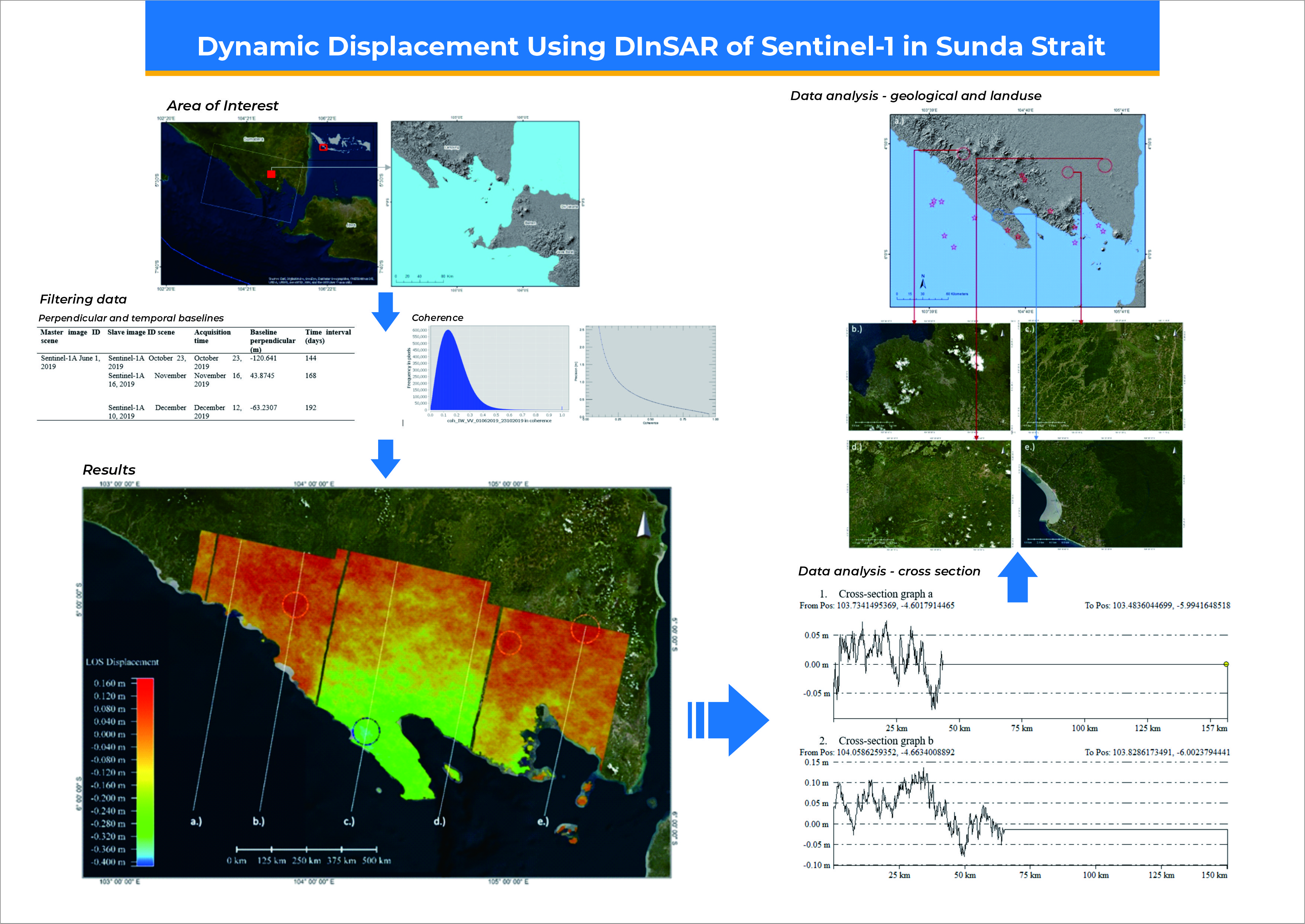
Downloads
References
M Abdurrachman, S Widiyantoro, B Priadi and T Ismail. Geochemistry and structure of krakatoa volcano in the Sunda Strait, Indonesia. Geosciences 2018; 8, 111.
A Julzarika, DP Laksono, L Subehi, EK Dewi, K Kayat, HA Sofiyuddin and MFI Nugraha. Comprehensive integration system of saltwater environment on Rote Island using a multidisciplinary approach. J. Degraded Min. Lands Manag. 2018; 6, 1553-67.
KR Newcomb and WR Mccann. Seismic history and seismotectonics of the Sunda Arc. J. Geophys. Res. 1987; 92, 421-39.
AG Suhadha and A Julzarika. Integration of remote sensing and geographic information system for mapping potential tsunami inundation. In: Proceedings of the 2020 IEEE Asia-Pacific Conference on Geoscience, Electronics and Remote Sensing Technology, Jakarta, Indonesia. 2020, p. 163-7.
LD Setijadji. Segmented volcanic arc and its association with geothermal fields in Java Island, Indonesia. In: Proceedings of the proceedings world geothermal congress 2010, Bali, Indonesia. 2010.
KE Bradley, L Feng, EM Hill, DH Natawidjaja and K Sieh. Implications of the diffuse deformation of the indian ocean lithosphere for slip partitioning of oblique plate convergence in Sumatra. J. Geophys. Res. 2017; 122, 579-91.
R Williams, P Rowley and MC Garthwaite. Reconstructing the anak krakatau flank collapse that caused the december 2018 indonesian tsunami. Geology 2019; 47, 973-6.
HZ Abidin, H Andreas, I Gumilar, TP Sidiq and Y Fukuda. On the roles of geospatial information for risk assessment of land subsidence in urban areas of Indonesia. In: S Zlatanova, R Peters, A Dilo and H Scholten (Eds.). Intelligent systems for crisis management. Springer Science & Business Media, Berlin, Germany, 2013, p. 277-88.
I Gumilar, HZ Abidin, TP Sidiq, H Andreas, R Maiyudi and M Gamal. Mapping and evaluating the impact of land subsidence in semarang (indonesia). Indonesian J. Geospatial 2013; 2, 26-41.
A Ferretti. Satellite InSAR data: Reservoir monitoring from space. European Association of Geoscientists and Engineers, Kuala Lumpur, Malaysia, 2014, p. 1-160.
Q Huang, M Crosetto, O Monserrat and B Crippa. Displacement monitoring and modelling of a high-speed railway bridge using C-band Sentinel-1 data. ISPRS J. Photogram Rem. Sens. 2017; 128, 204-11.
P Jeanne, M Crosetto, O Monserrat and B Crippa. Role of agricultural activity on land subsidence in the san joaquin valley, california. J. Hydrol. 2018; 569, 462-9.
S Schindler, F Hegemann, C Koch, M König and P Mark. Radar interferometry based settlement monitoring in tunnelling: Visualisation and accuracy analyses. Visual. Eng. 2016; 4, 7.
A Aditiya, Y Aoki and RD Anugrah. Surface deformation monitoring of Sinabung volcano using multi temporal InSAR method and GIS analysis for affected area assessment. IOP Conf. Ser. Earth Environ. Sci. 2018; 344, 012003.
A Agustan, RN Hanifa, Y Anantasena, M Sadly and T Ito. Ground deformation identification related to 2018 lombok earthquake series based on Sentinel-1 data. IOP Conf. Ser. Earth Environ. Sci. 2019; 280, 012004.
AG Suhadha, A Julzarika, M Ardha and F Chusnayah. Monitoring vertical deformations of the coastal city of palu after earthquake 2018 using Parallel-SBAS. In: Proceedings of the 2021 7th Asia-Pacific Conference on Synthetic Aperture Radar, Bali, Indonesia. 2021.
AM Lubis. Uplift of kelud volcano prior to the november 2007 eruption as observed by L-band insar. J. Eng. Technol. Sci. 2014; 46, 245-57.
J Widodo, A Herlambang, A Sulaiman and P Razi. Land subsidence rate analysis of jakarta metropolitan region based on D-InSAR processing of sentinel data C-Band frequency land subsidence rate analysis of jakarta metropolitan region based on D-InSAR processing of sentinel data C-Band frequency. J. Phys. Conf. Ser. 2019; 1185, 012004.
M Ardha, AG Suhadha, A Julzarika, F Yulianto, D Yudhatama and RZ Darwista. Utilization of sentinel-1 satellite imagery data to support land subsidence analysis in DKI Jakarta. J. Degraded Min. Lands Manag. 2021; 8, 2587-93.
M Tzouvaras, C Danezis and DG Hadjimitsis. Differential SAR interferometry using sentinel‐1 imagery‐limitations in monitoring fast moving landslides: The case study of cyprus. Geosciences 2020; 10, 1-25.
European Space Agency. Sentinel-1 heritage 2020, Available at: https://sentinel.esa.int/web/sentinel/missions/sentinel-1/heritage, accessed May 2020.
European Space Agency. Sentinel-1 mission 2020, Available at: https://sentinel.esa.int/web/sentinel/missions/sentinel-1, accessed May 2020.
A Sowter, MBC Amat, F Cigna, S Marsh, A Athab and L Alshammari. Mexico city land subsidence in 2014-2015 with Sentinel-1 IW TOPS: Results using the intermittent SBAS (ISBAS) technique. Int. J. Appl. Earth Observation Geoinformation 2016; 52, 230-42.
U.S. Geological Survey. EXPO-CAT earthquake catalog, earthquake catalog epicenters, Available at: http://earthquake.usgs.gov/research/pager/data/expocat.php, accessed May 2020.
N Liosis, PR Marpu, K Pavlopoulos and TBMJ Ouarda. Ground subsidence monitoring with SAR interferometry techniques in the rural area of Al Wagan, UAE. Rem. Sens. Environ. 2018; 216, 276-88.
SN Madsen and HA Zebker. Automated absolute phase retrieval in. In: Proceedings of the IGARSS’ 92 International Geoscience and Remote Sensing Symposium, Texas, United States. 1992, p. 1582-4.
A Pepe and F Calò. A review of interferometric synthetic aperture RADAR (InSAR) multi-track approaches for the retrieval of Earth’s surface displacements. Appl. Sci. 2017; 7, 1264.
IM Anjasmara and NU Muthmainnah. Analisis deformasi pulau madura dari pengolahan data SAR menggunakan metode DInSAR. Geoid J. Geodes. Geomatics 2018; 14, 103.
D Massonnet and KL Feigl. Radar interferometry and its application to changes in the earth’s surface. Rev. Geophys. 1998; 36, 441-500.
Badan Meteorologi, Klimatologi, dan Geofisika. Repository gempabumi, Available at: http://repogempa.bmkg.go.id/repo_new/repository.php, accessed June 2020.
ESRI database 2020, Available at: http://goto.arcgisonline.com/maps/World_Imagery, accessed June 2020.
S Widada, M Zainuri, G Yulianto, S Saputra and B Rochaddi. Distributian of depth and clay-silt to sand ratio of land subsidence in coastal semarang city by resistivity methods. J. Kelautan Tropis 2019; 22, 63-8.
HZ Abidin, H Andreas, I Gumilar, TP Sidiq and Y Fukuda. Land subsidence in coastal city of Semarang (Indonesia): Characteristics, impacts and causes. Geomatics Nat. Hazards Risk 2013; 4, 226-40.
Downloads
Published
How to Cite
Issue
Section
License

This work is licensed under a Creative Commons Attribution-NonCommercial-NoDerivatives 4.0 International License.