
Characteristics of Waters during Transitional Season, Senimba Waters
DOI:
https://doi.org/10.48048/tis.2022.4495Keywords:
Senimba bay, Oceanography, ECMWF, ADCP, Least-squareAbstract
Characteristics of Waters During Transitional Season, Senimba Bay, Batam Indonesia. Senimba Bay is a water area in Batam City. It is necessary to develop the waters of Senimba Bay due to its location around the bay, which is still not arranged. Development such as changes in sea transportation lines and structuring the bay area requires Hidro-oceanography data, such as current data, waves, tides, and bathymetry. The research discusses the Gulf of Senimba waters' characteristics in the transition season, namely in April-May. The primary data taken is current data, bathymetry, waves, tides, and secondary data is wind data from ECMWF. Retrieval of current and wave data using ADCP (Acoustic Doppler Current Profiler) with several layers of depth. The method used for tides is Least-Square. Flow in the transition season in the Gulf of Senimba waters has a southwest direction during the high tide and northeast when low tides with mixed tides are double inclines, and the direction of the wind blows dominant towards the northeast. These waters have a minimum depth of –12.60 m Mean Sea Level (MSL) and maximum value –0.03 m MSL with current modeling. It produces no significant changes and only occurs in the direction of current in specific locations because location bathymetry factors influence it.
HIGHLIGHTS
- Construction and shipping lanes are in dire need of hydro-oceanographic data processing, especially in industrial areas
- The characteristics of the waters are very important to be seen every season of the year, this greatly determines the patterns and characteristics of waters
- The waters of Senimba Bay, Batam are more dominant in producing sea surface currents caused by winds that point to the northeast
- The depth of the sea is very important to get in doing hydro-oceanographic data modeling, this really determines the level of accuracy of the resulting model data
GRAPHICAL ABSTRACT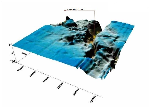
Downloads
References
H Thoha. Pengaruh musim terhadap plankton di perairan Riau Kepulauan dan sekitarnya. Makara J. Sci. 2003; 7, 59-70.
IW Abida. Struktur komunitas dan kelimpahan fitoplankton di perairan muara sungai porong sidoarjo. jurnal kelautan. Indones. J. Sci. Technol. 2010; 3, 36-40.
Al Tanto, T Wisha, UJ Kusumah, G Pranowo, WS Husrin, SI Ilham and A Putra. Karakteristik arus laut perairan teluk benoa-bali. Jurnal Ilmiah Geomatika 2017; 23, 37-48.
M Syahdan, AS Atmadipoera, SB Susilo and JL Gaol. Variability of surface chlorophyll-A in the Makassar Strait-Java Sea, Indonesia. Int. J. Sci. Basic Appl. Res. 2014; 14, 103-16.
UJ Wisha, S Husrin and J Prihantono. Hydrodynamics banten bay during transitional seasons (august-september) (hidrodinamika perairan teluk banten pada musim peralihan. Indonesian J. Mar. Sci. 2015; 20, 101-12.
X Zhang and JA Church. Sea level trends, interannual and decadal variability in the Pacific Ocean. Geophys. Res. Lett. 2012; 39.
A Atmadipoera, R Molcard, G Madec, S Wijffels, J Sprintall. A Koch-Larrouy and A Supangat. Characteristics and variability of the Indonesian throughflow water at the outflow straits. Deep-Sea Res. I: Oceanogr. Res. Pap. 2009; 56, 1942-54.
SM Maxwell, EL Hazen, RL Lewison, DC Dunn, H Bailey, SJ Bograd and S Benson. Dynamic ocean management: Defining and conceptualizing real-time management of the ocean. Mar. Policy 2015; 58, 42-50.
M Zhang and HV Storch. Toward downscaling oceanic hydrodynamics-suitability of a high-resolution OGCM for describing regional ocean variability in the South China Sea. Oceanologia. 2017; 59, 166-76.
A Koch-Larrouy, G Madec and D Iudicone, A Atmadipoera and R Molcard. Physical processes contributing to the water mass transformation of the Indonesian throughflow. Ocean Dyn. 2008; 58, 275-88.
M Li, AL Gordon, J Wei, LK Gruenburg, G Jiang. Multi-decadal timeseries of the Indonesian throughflow. Dyn. Atmospheres Oceans. 2018; 81, 84-95.
MZ Lubis and U Amri. Beach profile (oceanography factors) of Labuhan Bilik Island, Aruah Island, Rokan Hilir District, Indonesia. In: Proceedings of the International Conference on Applied Engineering, Batam, Indonesia. 2018, p. 1-6.
MZ Lubis and AP Daya. Pemetaan parameter oseanografi fisik menggunakan citra landsat 8 di wilayah perairan nongsa pulau batam. J. Integrasi. 2017; 9, 9-15.
H Coelho and R Santos. Enhanced primary production over seamounts: A numerical study. Thalassas 2003; 19, 144-5.
VS Kumar, CS Philip and TB Nair. Waves in shallow water off west coast of India during the onset of summer monsoon. Ann. Geophys. 2010; 28, 817-24.
H Jiang and G Chen. A global view on the swell and wind sea climate by the Jason-1 mission: A revisit. J. Atmos. Ocean. Technol. 2013; 30, 1833-41.
ZX Wei, GH Fang, RD Susanto, TR Adi, B Fan, A Setiawan and XM Gao. Tidal elevation, current and energy flux in the area between the South China Sea and Java Sea. Ocean Sci. Discuss. 2015; 12, 517-31.
A Pamungkas. Karakteristik parameter oseanografi (pasang-surut, arus, dan gelombang) di Perairan Utara dan Selatan Pulau Bangka. Buletin Oseanografi Marina 2018; 7, 51-8.
A Pamungkas and MA Farhaby. Hydro-oceanography modelling characteristic (tides, waves, and currents) in Kelabat Bay, Bangka Belitung. In: Proceedings of the International Conference on Maritime and Archipelago, Bangka Belitung, Indonesia. 2018, p. 401.
MZ Lubis, W Anurogo, MA Mufida, H Taki, SM Antoni and RA Lubis. Physical condition of the ocean to global climate change variability: Case study in the Batam waters, Indonesia. In: Proceedings of the International Conference on Applied Engineering, Batam, Indonesia. 2018, p. 1-4.
A Riyadi and M Santos. Kondisi oseanografi di selat matak kabupaten kepulauan anambas melalui model hidrodinamika. Ilmu kelautan: Indonesian J. Mar. Sci. 2014; 20, 101-12.
Downloads
Published
How to Cite
Issue
Section
License

This work is licensed under a Creative Commons Attribution-NonCommercial-NoDerivatives 4.0 International License.