
The Combination of Hvsr and Masw Methods with Landsat 8 Imagery to Assess the Changing Shoreline along the Coastal Area of Central Bengkulu
DOI:
https://doi.org/10.48048/tis.2024.7544Keywords:
Central Bengkulu regency, HVSR method, Landsat-8, MASW method, Shoreline changeAbstract
The Central Bengkulu Regency possesses a coastline measuring 21.8 km, situated in direct proximity to the Indian Ocean. The heightened wave and ocean current dynamics possess the capacity to induce detrimental effects in the form of coastal abrasion along the coastline. This study conducted an examination of the rate of shoreline changes resulting from coastal abrasion in Central Bengkulu Regency, Bengkulu, Indonesia. Horizontal-to-vertical spectral ratio (HVSR) analysis, multichannel analysis of surface waves (MASW), and Landsat-8 remote sensing were all used in the current investigation. The project gets started with conducting field investigations and measurements of geophysical techniques, including the collection of Landsat-8 satellite imagery spanning the period from 1990 to 2020. Additionally, an examination was conducted on the rate at which the shoreline undergoes changes in velocity. In order to determine the increase in change that occurs along coastlines over a period of several decades, a study was carried out during which Landsat-8 satellite images were analyzed. This study investigates the application of the HVSR technique for assessing the seismic vulnerability of the ground and, additionally, the MASW technique for measuring the shear wave velocity of the coastline’s soil. Both of these methodologies are compared and contrasted with one another in this research. The findings indicated that the mean pace of coastline change in Central Bengkulu Regency was 1.5 m/yr, with the maximum velocity recorded at 4.1 m/yr. This high velocity of shoreline change is correlated with the Vs30 value of MASW measurement and Kg of HVSR measurement, where the subsurface soil structure along the coast of Central Bengkulu Regency from Vs30 measurement shows that it is dominated by stiff soil structure that is susceptible to erosion. Outcomes from the study can inform decision-making processes about safeguards and preventative measures to prevent further coastal degradation.
HIGHLIGHTS
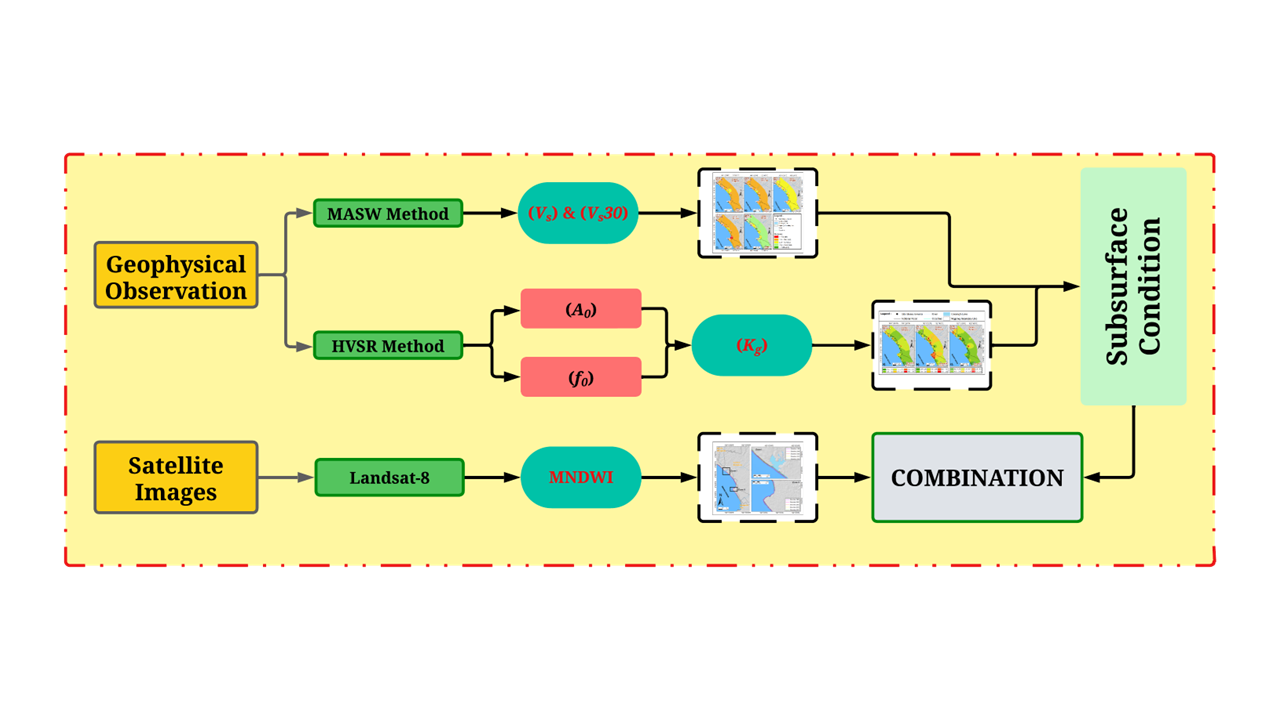
- In this paper, we present a framework using application passive and active seismic method with Landsat 8 for knowing the changing of shoreline coastal area in Central Bengkulu Indonesia
- This study demonstrated that the high velocity of the shifting shoreline is correlated with Vs30 and Kg values
- The subsurface soil structure is predominantly composed of stiff soil, and the changing shoreline starts at 1.5 mm/yr, which makes the coast of Central Bengkulu vulnerable to erosion
GRAPHICAL ABSTRACT
Downloads
References
R Rostika, NP Purba, M Lutfi, J Kelvin and I Silalahi. The managing plan for abrasion in coastal area of Garut Regency. Procedia Environ. Sci. 2016; 33, 512-9.
DND Pratama, N Khakhim, A Wicaksono, A Musthofa and W Lazuardi. Spatio-temporal analysis of abrasion susceptibility effect on land cover in the coastal area of Bantul Regency, Yogyakarta, Indonesia. Int. J. Geoinformatics 2021; 17, 109-26.
UJ Wisha, R Dhiauddin, K Ondara, WA Gemilang and GA Rahmawan. Assessing urban development impacts in the Padang Coastline City, West Sumatra Indonesia; coastline changes and coastal vulnerability. Geoplanning 2022; 9, 73-88.
Statistics of Bengkulu Tengah Regency. Bengkulu Tengah Regency in figures 2023. Statistics of Bengkulu Tengah Regency, Bengkulu, Indonesia, 2023.
P Vinayaraj, G Johnson, GD Udhaba, CS Philip, VS Kumar and R Gowthaman. Quantitative estimation of coastal changes along selected locations of Karnataka, India: A GIS and remote sensing approach. Int. J. Geosci. 2011; 2, 385-93.
A Gracia, N Rangel-Buitrago, JA Oakley and AT Williams. Use of ecosystems in coastal erosion management. Ocean Coast Manag. 2018; 156, 77-89.
LCV Rijn. Coastal erosion and control. Ocean Coast Manag. 2011; 54, 67-87.
DH Prasad and ND Kumar. Coastal erosion studies - a review. Int. J. Geosci. 2014; 5, 341-5.
N Moursy. Hazards and risk assessments of coastal erosion. J. Coast. Zone Manag. 2022; 25, 1000505.
SGMD Hashmi and SR Ahmad. GIS-based analysis and modeling of coastline erosion and accretion along the Coast of Sindh Pakistan. J. Coast. Zone Manag. 2018; 21, 1000455.
HA Banumathi and SP Jeyapriya. A numerical study on hydrodynamic and liquefaction analysis of coastline protected with geotubes. In: K Muthukkumaran, R Ayothiraman and S Kolathayar (Eds.). Soil dynamics, earthquake and computational geotechnical engineering IGC 2021 lecture notes in civil engineering. Vol 300. Springer, Singapore, 2023.
AM Lubis, R Hanapi, J Sinaga, R Samdara and B Harlianto. Estimating shoreline changes at coastal region of North Bengkulu Regency using unmanned aerial vehicle (UAV). Majalah Ilmiah Globë 2022; 24, 81-9.
FA Maulana, K Amri and B Besperi. Prediksi perubahan garis pantai Bengkulu (Studi kasus pantai Zakat Kota Bengkulu). Jurnal Peradaban Sains, Rekayasa dan Teknologi 2021; 9, 15-22.
R Oktami. 2016, Changes in beach area in Southern Bengkulu Province using landsat satellite image data. Bachelor Thesis. University of Bengkulu, Bengkulu, Indonesia.
Supiyati, B Sulistyo and R Oktami. Analisis perubahan garis pantai Kabupaten Kaur Provinsi Bengkulu selama 10 tahun (2006 - 2016). Prosiding Seminar Nasional Fisika (E-Journal) 2017; 6, SNF2017-EPA.
DJ Sherman and BO Bauer. Coastal geomorphology through the looking glass. Geomorphology 1993; 7, 225-49.
PJ Zuzek, RB Nairn and SJ Thieme. Spatial and temporal considerations for calculating shoreline change rates in the Great Lakes Basin. J. Coast. Res. 2003; 38, 125-46.
R Gens. Remote sensing of coastlines: Detection, extraction and monitoring. Int. J. Remote Sens. 2010; 31, 19-36.
N Adebisi, AL Balogun, M Mahdianpari and TH Min. Assessing the impacts of rising sea level on coastal morpho-dynamics with automated high-frequency shoreline mapping using multi-sensor optical satellites. Remote Sens. 2021; 13, 3587.
DN Quang, VH Ngan, HS Tam, NT Viet, NX Tinh and H Tanaka. Long-term shoreline evolution using dsas technique: A case study of Quang Nam Province, Vietnam. J. Mar. Sci. Eng. 2021; 9, 1124.
AY Yiğit, Y Kaya and IH Şenol. Monitoring the change of Turkey’s tourism city Antalya’s Konyaaltı shoreline with multi-source satellite and meteorological data. Appl. Geomatics 2022; 14, 223-36.
H Xu. Modification of normalised difference water index (NDWI) to enhance open water features in remotely sensed imagery. Int. J. Remote Sens. 2006; 27, 3025-33.
CB Park, RD Miller and J Xia. Multi-channel analysis of surface waves using Vibroseis (MASWV). SEG Tech. Program Expanded Abstr. 1996, https://doi.org/10.1190/1.1826742.
J Xia, R Cakir, RD Miller, C Zeng and Y Luo. Estimation of near-surface shear-wave velocity by inversion of Love waves. In: Proceedings of the 79th Society of Exploration Geophysicists International Exposition and Annual Meeting, Texas, USA. 2009, p. 1390-5.
Y Nakamura. Real time information systems for seismic hazards mitigation UrEDAS, HERAS, PIC. Q Rep. Railw. Tech. Res. Inst. 1996; 37, 112-27.
I Akkaya. Availability of seismic vulnerability index (Kg) in the assessment of building damage in Van, Eastern Turkey. Earthquake Eng. Eng. Vib. 2020; 19, 189-204.
AM Al-Amri, K Abdelrahman and MS Fnais. Evaluation of seismic vulnerability index in Makkah Al-Mukarramah Urban Area, Saudi Arabia, using microtremor measurements. Arab. J. Geosci. 2022; 15, 1350.
MMR Bhuiya and W Shao. Perceptions of earthquake risks and knowledge about earthquake response among movement challenged persons in Dhaka City of Bangladesh. Int. J. Disaster Risk Reduct. 2022;70, 102743.
JG Anderson, Y Lee, Y Zeng and S Day. Control of strong motion by the upper 30 meters. Bull. Seismol. Soc. Am. 1996; 86, 1749-59.
S Park and S Elrick. Predictions of shear-wave velocities in Southern California using surface geology. Bull. Seismol. Soc. Am. 1998; 88, 677-85.
E Soebowo, D Sarah and A Tohari. Geologi Bawah permukaan kaitannya dengan potensi likuifaksi di daerah Bengkulu. In: Proceedings of the Pertemuan Ilmiah Tahunan Iagi Ke-37, Bandung, Indonesia. 2008.
S Gafoer, TC Amin and R Pardede. Geological map of the Bengkulu Quadrangle, Sumatera. Pusat Penelitian dan Pengembangan Geologi, Bandung, Indonesia, 2012.
A Sandhyavitri, F Fatnanta, RR Husaini and I Suprayogi. Combination of a coastal vulnerability index (CVI) and social economic approaches in prioritizing the development of Riau Coastlines, Indonesia. MATEC Web Conf. 2019; 276, 02006.
HM Miller. Users and uses of landsat 8 satellite imagery-2014 survey results. United States Geological Survey, Washington DC, USA, 2016.
AM Marangoz, A Sekertekin and HAkçin. Analysis of land use land cover classification results derived from sentinel-2 image. In: Proceedings of the 17th International Multidisciplinary Scientific GeoConference, Albena, Bulgaria. 2017, p. 25-32.
J Laonamsai, P Julphunthong, T Saprathet, B Kimmany, T Ganchanasuragit, P Chomcheawchan and N Tomun. Utilizing NDWI, MNDWI, SAVI, WRI, and AWEI for estimating erosion and deposition in Ping River in Thailand. Hydrology 2023; 10, 70.
C Huang, Y Chen, S Zhang and J Wu. Detecting, extracting, and monitoring surface water from space using optical sensors: A review. Rev. Geophys. 2018; 56, 33-60.
S Szabó, Z Gácsi and B Balázs. Specific features of NDVI, NDWI and MNDWI as reflected in land cover categories. Landsc. Environ. 2016; 10, 194-202.
M Nogoshi and T Igarashi. On the propagation characteristics of microtremor. J. Seismol. Soc. Jpn. 1970; 23, 64-80.
Y Nakamura. A method for dynamic characteristics estimation of subsurface using micrometers on the ground surface. Railw. Tech. Res. Inst. Q. Rep. 1989; 30, 25-33.
M Wathelet, JL Chatelain, C Cornou, GD Giulio, B Guillier, M Ohrnberger and A Savvaidis. Geopsy: A user-friendly open-source tool set for ambient vibration processing. Seismol. Res. Lett. 2020; 91, 1878-89.
SESAME. Guidelines for the implementation of the H/V spectral ratio technique on ambient vibrations-measurements, processing and interpretations. SESAME European Research Project WP12, 2004, p. 1-64.
K Konno and T Ohmachi. Ground-motion characteristics estimated from spectral ratio between horizontal and vertical components of microtremor. Bull. Seismol. Soc. Am. 1998; 88, 228-41.
E Pamuk, T Gönenç, ÖC Özdağ and M Akgün. 3D bedrock structure of bornova plain and its surroundings (İzmir/Western Turkey). Pure Appl. Geophys. 2018; 175, 325-40.
E Pamuk, ÖC Özdağ, A Tunçel, Ş Özyalın and M Akgün. Local site effects evaluation for Aliağa/İzmir using HVSR (Nakamura technique) and MASW methods. Nat. Hazards 2018; 90, 87-99.
Y Nakamura. Seismic vulnerability indices for ground and structures using microtremor. In: Proceedings of the World Congress on Railway Research, Firenze, Italy. 1997.
Y Nakamura. Clear identification of fundamental idea of nakamura’s technique and its applications. In: Proceedings of the 12th World Conference on Earthquake Engineering, New Zealand. 2000.
TF Abdallatif, AA Khozym and AA Ghandour. Determination of seismic site class and potential geologic hazards using multi-channel analysis of surface waves (MASW) at the industrial city of Abu Dhabi, UAE. NRIAG J. Astron. Geophys. 2022; 11, 193-209.
MAM Ashraf, NS Kumar, R Yusoh, ZAM Hazreek and M Aziman. Site classification using multichannel channel analysis of surface wave (MASW) method on soft and hard ground. J. Phys. Conf. Ser. 2018; 995, 012108.
S Foti, F Hollender, F Garofalo, D Albarello, M Asten, PY Bard, C Comina, C Cornou, B Cox, GD Giulio, T Forbriger, K Hayashi, E Lunedei, A Martin, D Mercerat, M Ohrnberger, V Poggi, F Renalier, D Sicilia and V Socco. Guidelines for the good practice of surface wave analysis: A product of the InterPACIFIC project. Bull. Earthquake Eng. 2018; 16, 367-420.
G Cao, W Wang, G Yin and Z Wei. Experimental study of shear wave velocity in unsaturated tailings soil with variant grain size distribution. Constr. Build. Mater. 2019; 228, 116744.
W Duan, G Cai, S Liu and AJ Puppala. Correlations between shear wave velocity and geotechnical parameters for Jiangsu Clays of China. Pure Appl. Geophys. 2019; 176, 69-84.
Badan Standarisasi Nasional. Tata cara perencanaan ketahanan gempa untuk struktur bangunan gedung dan nongedung. Badan Standarisasi Nasional, Jakarta, Indonesia, 2019.
EH Boak and IL Turner. Shoreline definition and detection: A review. J. Coast Res. 2005; 214, 688-703.
PW French. Coastal defences: Processes, problems and solutions. Routledge, London, 2001.
JAG Cooper and OH Pilkey. Pitfalls of shoreline stabilization: Selected case studies. Springer, Dordrecht, Western Netherlands, 2012.
KF Nordstrom. Living with shore protection structures: A review. Estuar. Coast. Shelf Sci. 2014; 150, 11-23.
Downloads
Published
How to Cite
Issue
Section
License
Copyright (c) 2023 Walailak University

This work is licensed under a Creative Commons Attribution-NonCommercial-NoDerivatives 4.0 International License.