
Lake Water Quality Assessment Through GIS based Interpolation Method: A Case Study of Beris Dam, Kedah, Malaysia
DOI:
https://doi.org/10.48048/tis.2024.7333Keywords:
Physicochemical, Water quality index, Carlson trophic state index (CTSI), Interpolation, IDW, Kriging, Spline, CorrelationAbstract
Preliminary research on physicochemical and water quality in the Beris dam shows that the water catchment area has the best standards and quality during the observation of the wet season and dry season mainly in the northern states of peninsular Malaysia. The analysis of water quality assessment using the DOE-WQI and Carlson Trophic State Index (CTSI) resulted that during the dry season (February), the average DOE-WQI reading is 88 or Class II; while during the wet season, the average DOE-WQI reading recorded 87.1 (October). Although the CTSI score was 34.2 - 27.0 during wet season and dry season, both seasons were classified as oligotrophic conditions. Some physicochemical parameters also show a high correlation between them and indicates minor water quality issues. The use of more efficient interpolation techniques in water quality studies also reinforces the evaluation of water quality. As a reference point for future water research, GIS interpolation application methods can be more effectively and efficiently used with Inverse Distance Weighted (IDW), Ordinary Kriging and Spline techniques.
HIGHLIGHTS
- Investigation of physicochemical and water quality in lake water in Beris Dam
- Assessment by using water quality index by DOE-WQI and Carlson Trophic State Index (CTSI) to acknowledge water quality and trophic condition.
- Analyzing physicochemical data into mathematical method to compare between physicochemical data and correlate between them.
- Application of GIS based interpolation methods to analyze and referencing physicochemical data into spatial interpolation maps.
- Comparing appropriate spatial interpolation techniques to analyze physicochemical observation data and index.
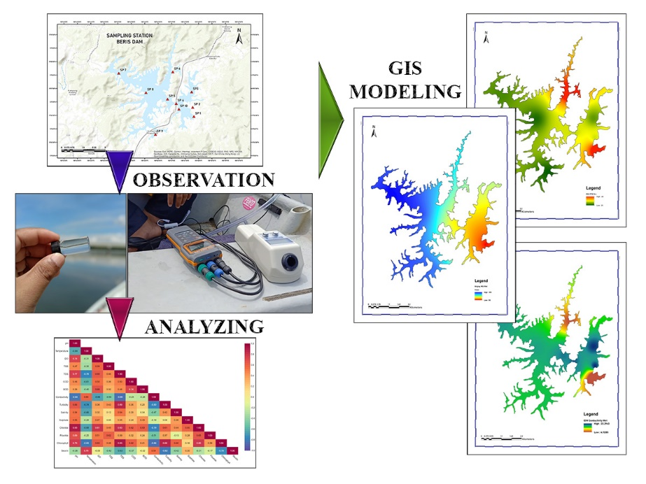
GRAPHICAL ABSTRACT

Downloads
References
B Pant, VGB Lohani, V Lohani, MD Trakroo and H Tewari. Study of water quality by physicochemical analysis of a Himalayan Lake of Uttarakhand, India. Ecol. Environ. Conservat. 2017; 23, 1128-34.
M Camara, NR Jamil and AFB Abdullah. Impact of land uses on water quality in Malaysia: A review. Ecol. Process. 2019; 8, 10.
V Kothari, S Vij, SK Sharma and N Gupta. Correlation of various water quality parameters and water quality index of districts of Uttarakhand. Environ. Sustain. Indicat. 2021; 9, 100093.
A Asmat, NA Hazali, ANM Nor and FK Zuhan. Seasonal-spatial of putrajaya lake water quality parameter (WQP) concentration using geographic information system (GIS). Int. J. Eng. Tech. 2018; 7, 176.
R Nagalakshmi, K Prasanna and SP Chandar. Water quality analysis using GIS interpolation method in serthalaikadu Lagoon, east coast of India. Rasayan J. Chem. 2016; 9, 634-40.
MSM Abdullah, MB Hapani, NFM Salleh and WMSW Alias. Ecosystem health assessment of Sungai Pengkalan Chepa basin: Water quality and heavy metal analysis. Sains Malaysiana 2020; 49, 1787-98.
AGD Prasad and Siddaraju. Carlson’s trophic state index for the assessment of trophic status of two Lakes in Mandya district. Adv. Appl. Sci. Res. 2012; 3, 2992-6.
DLB Stephens, RE Carlson, CA Horsburgh, MV Hoyer, RW Bachmann and DE Canfield. Regional distribution of Secchi disk transparency in waters of the United States. Lake Reservoir Manag. 2015; 31, 55-63.
A Mustapha and A Abdu. Application of principal component analysis & multiple regression models in surface water quality assessment. J. Environ. Earth Sci. 2012; 2, 16-23.
A Saturday, TJ Lyimo, J Machiwa and S Pamba. Spatio-temporal variations in physicochemical water quality parameters of Lake Bunyonyi, Southwestern Uganda. SN Appl. Sci. 2021; 3, 684.
M Khan, MMA Almazah, A EIlahi, R Niaz, AY Al-Rezami and B Zaman. Spatial interpolation of water quality index based on Ordinary kriging and Universal kriging. Geomatics Nat. Hazards Risk 2023; 14, 2190853.
MFU Saifuddin, ZH Ash’aari, AZ Aris and Z Diyana. GIS-based risk assessment of tropical surface water pollution by integrating hydrogeological and anthropogenic parameters. Hum. Ecol. Risk Assess. 2023; 29, 651-78.
TK Chakraborty, S Islam, GC Ghosh, P Ghosh, S Zaman, A Habib, R Hossain, H Bosu, R Islam, MA Imran, AS Khan and SK Josy. Human health risk and hydro-geochemical appraisal of groundwater in the southwest part of Bangladesh using GIS, water quality indices, and multivariate statistical approaches. Toxin Rev. 2023; 42, 285-99.
J Naymik, CA Larsen, R Myers, C Hoovestol, N Gastelecutto and D Bates. Long-term trends in inflowing chlorophyll a and nutrients and their relation to dissolved oxygen in a large western reservoir. Lake Reservoir Manag. 2023; 39, 53-71.
L Durell, JT Scott and AS Hering. Hybrid forecasting for functional time series of dissolved oxygen profiles. Data Sci. Sci. 2023; 2, 2152401.
American Public Health Association, American Water Works Association and Water Environment Federation. Standard methods for the examination of water and wastewater. Copyright, Washington DC, 1999.
The Executive Director Office of the Federal Register. APHA method 4110: Standard methods for the examination of water and wastewater. Copyright, Washington DC, 2023.
P Ikefuti, LV Barrozo and A Braga. An ecological study of the relationship between mean temperature and mortality for stroke in elderly people. ISEE Conf. Abstr. 2015; 2015, 1096.
NZ Arman, MIM Said, S Salmiati and S Azman. Comparison between water quality index (WQI) and biological water quality index (BWQI) for water quality assessment: Case study of Melana River, Johor. Malays. J. Anal. Sci. 2013; 17, 224-9.
ANNEX, Available at: https://www.doe.gov.my/wp-content/uploads/2021/09/standard-kualiti-air-sungai-kebangsaan-dan-indeks-kualiti-air-sungai.pdf, accessed July 2023.
M Dhanasekarapandian, S Chandran, DS Devi and V Kumar. Spatial and temporal variation of groundwater quality and its suitability for irrigation and drinking purpose using GIS and WQI in an urban fringe. J. Afr. Earth Sci. 2016; 124, 270-88.
Water Quality Standards and Indices, Available at: https://enviro2.doe.gov.my/ekmc/wp-content/uploads/2021/04/Slaid-Dr-Zaki-Zainudin-Water-Quality-Standards-and-Indices.pdf, accessed May 2022.
K Kim, B Kim, KH Knorr, J Eum, Y Choi, S Jung and S Peiffer. Potential effects of sediment processes on water quality of an artificial reservoir in the Asian monsoon region. Inland Waters 2016; 6, 423-35.
DCM Pin, X Guo, K Wang, LM Chng, LP Wong and X Zhao. Assessment of water eutrophication in Kampar, Malaysia. AIP Conf. Proc. 2019; 2157, 020022.
RE Carlson. A trophic state index for lakes. Limnol. Oceanogr. 1977; 22, 361-9.
G Achilleos. Errors within the inverse distance weighted (IDW) interpolation procedure. Geocarto Int. 2008; 23, 429-49.
J Li and AD Heap. Spatial interpolation methods applied in the environmental sciences: A review. Environ. Model. Software 2014; 53, 173-89.
A Mohammadi, M Faraji, SN Mansour, A Abdolahnejad and M Miri. Spatial analysis of heavy metals in surface soil, NW Iran. Int. J. Environ. Anal. Chem. 2023; 103, 354-63.
P Subramaniam, AN Ahmed, CM Fai, MA Malek, P Kumar, YF Huang, M Sherif and A Elshafie. Integrated GIS and multivariate statistical approach for spatial and temporal variability analysis for lake water quality index. Cogent Eng. 2023; 10, 2190490.
PM Bartier and CP Keller. Multivariate interpolation to incorporate thematic surface data using inverse distance weighting (IDW). Comput. Geosci. 1996; 22, 795-9.
L Polina. Interpolation. Lemenkova Polina, Salzburg, Austria, 2010.
W Maleika. Inverse distance weighting method optimization in the process of digital terrain model creation based on data collected from a multibeam echosounder. Appl. Geomatics 2020; 12, 397-407.
J Kim, J Han, K Park and S Seok. Improved IDW interpolation application using 3D search neighborhoods: Borehole data-based seismic liquefaction hazard assessment and mapping. Appl. Sci. 2022; 12, 11652.
W Yang, Y Zhao, D Wang, H Wu, A Lin and L He. Using principal components analysis and idw interpolation to determine spatial and temporal changes of Surfacewater quality of Xin’Anjiang river in huangshan, china. Int. J. Environ. Res. Publ. Health 2020; 17, 2942.
IO Ferreira, DD Rodrigues, GRD Santos and LMF Rosa. Em superficies batimétricas: Idw ou krigagem? Boletim De Ciências Geodésicas 2017, https://doi.org/10.1590/S1982-21702017000300033.
Muslim, Rusdi and RY Mauliza. Comparison between natural neighbor interpolation method and spline interpolation method of arcgis in saline levels in banda aceh after one decade of tsunami disaster. RP2U, Acheh, Indonesia, 2015.
A Firas, F Jassim and A Hasan. Image interpolation using kriging technique for spatial data. Can. J. Image Process. Comput. Vis. 2013; 4, 16-21.
SW Zhang, CY Shen, XY Chen, HC Ye, YF Huang and S Lai. Spatial interpolation of soil texture using compositional kriging and regression kriging with consideration of the characteristics of compositional data and environment variables. J. Integr. Agr. 2013; 12, 1673-83.
AH Auchincloss, AVD Roux, DG Brown, TE Raghunathan and CA Erdmann. Filling the gaps: Spatial interpolation of residential survey data in the estimation of neighborhood characteristics. Epidemiology 2007; 18, 469-78.
A Lichtenstern. 2013, Kriging methods in spatial statistics. Bachelor Thesis. Technical University of Munich, Munich, Germany.
A Setianto and T Triandini. Comparison of kriging and inverse distance weighted (IDW) Interpolation methods in lineament extraction and analysis. J. Southeast Asian Appl. Geol. 2013; 5, 21-9.
BA Butler and RG Ford. Evaluating relationships between total dissolved solids (TDS) and total suspended solids (TSS) in a mining-influenced watershed. Mine Water Environ. 2018; 37, 18-30.
MM Gibbs, E Bowman, KA Safi, AM Albert, IC Duggan and D Burger. Factors influencing summer phytoplankton biomass in a large river system with impoundments: Retention time, zooplankton grazing, thermal stratification and internal searching in a hydro lake. New Zeal. J. Mar. Freshwat. Res. 2023, https://doi.org/10.1080/00288330.2023.2177313
Downloads
Published
How to Cite
Issue
Section
License
Copyright (c) 2023 Walailak University

This work is licensed under a Creative Commons Attribution-NonCommercial-NoDerivatives 4.0 International License.