
Application of ERT, IP and VLF-EM Methods to Investigate Landslide-Prone Structures at Archaeological Sites in Lamreh, Aceh Besar, Indonesia
DOI:
https://doi.org/10.48048/tis.2024.7221Keywords:
Resistivity, Chargeability, Current density, Disaster mitigation, Cultural heritageAbstract
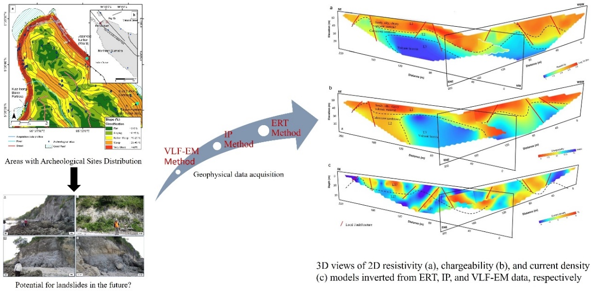
Since the 21st century, Lamreh, Aceh Besar Regency, Indonesia played an important role during the maritime silk route at the gate of the Malacca strait. This article investigates the subsurface structure of landslide-prone areas in cultural heritage based on 2D resistivity, chargeability and current density models of ERT, IP and VLF-EM methods, respectively. Field data measurements were carried out on 2 crossing profiles along the cliff suspected of experiencing landslides. The length of each profile is 220 with 4 m distance between stations. The 2D models reveal that the subsurface geological structure of Lamreh is composed of a mixed layer of clastic sediment and volcanic material at the top, followed by a layer of calcareous sandstone, and volcanic breccia at the bottom. The 3 layers are most easily distinguished in the resistivity model. The topmost layer is permeable but dry, i.e., characterized by a more resistive layer in the models. While the second layer is characterized by an intermediate conductivity and the bottom layer is highly conductive. The conductivity in these 2 layers is influenced by the degree of water content within the rocks. The chargeability models derived from IP data can distinguish between the dry layer on the surface and the saturated layer below. Meanwhile, the current density models obtained from VLF-EM data have proven the presence of fractures and faults along the profiles due to weathering as also seen in the resistivity models.
HIGHLIGHTS
- Investigation of subsurface structure in landslide-prone area of Lamreh, Aceh Besar Regency, Indonesia, a cultural heritage site with historical significance in the maritime silk route.
- Utilization of 2D resistivity, chargeability and current density models (ERT, IP and VLF-EM) to analyze the subsurface structure.
- Field data measurements conducted on 2 crossing profiles along the suspected landslide cliff, with a profile length of 220 and 4 m station distance.
- Subsurface geological structure of Lamreh identified as a mixed layer of clastic sediment and volcanic material at the top, followed by calcareous sandstone and volcanic breccia at the bottom.
- Resistivity models most effectively distinguish the 3 layers, highlighting permeable but dry top layer, intermediate conductivity in the second layer, and high conductivity in the bottom layer influenced by water content. Chargeability and current density models confirm surface dryness and presence of fractures and faults due to weathering
GRAPHICAL ABSTRACT

Downloads
References
EE McKinnon. Beyond serandib: A note on Lambri at the northern tip of Aceh. Indonesia 1988; 46, 103-21.
EE McKinnon. Aceh’s defences. Indonesia Malay World 2009; 37, 345-73.
EE McKinnon. Aceh and the maritime silk route: Aceh and Northern Sumatra, key locations on the ancient maritime silk route. In: D Qin and J Yuan (Eds.). Ancient silk trade routes. Institute of Southeast Asian Studies, Singapore, 2015, p. 149-68.
T Suarez. Early mapping of Southeast Asia: The epic story of seafarers, adventurers, and cartographers who first mapped the regions between China and India. Tuttle Publishing, Vermont, 2012.
JN Miksic and GG Yian. Ancient Southeast Asia. Taylor & Francis, New York, 2016.
RW Oetomo. Nisan plakpling, tipe nisan peralihan dari pra-islam ke islam. Berkala Arkeologi Sangkhakala 2007; 10, 68-76.
EE Mckinnon. Continuity and change in South Indian involvement in Northern Sumatra: The inferences of archaeological evidence from Kota Cina and Lamreh. In: PY Manguin, A Mani and G Wade (Eds.). Early interactions between South and Southeast Asia. ISEAS Publishing, Singapore, 2011, p. 137-60.
A Husni, Saryulis, H Ibrahim and M Saidin. An investigation of archaeological remains at Lamreh site, Aceh, Indonesia and their context within the Lamuri kingdom. Int. J. Asia Pac. Stud. 2019; 15, 59-88.
D Satria. Batu nisan lamreh tipe ‘plangpleng’. Berkala Arkeologi Sangkhakala 2019; 22, 65-80.
RM Feener, P Daly, E Edwards McKinnon, LL En-Ci, Ardiansyah, Nizamuddin, N Ismai, TY Seng, J Rahardjo and K Sieh. Islamisation and the formation of vernacular Muslim material culture in 15th century northern Sumatra. Indonesia Malay World 2021; 49, 1-41.
H Ibrahim, R Abdullah, S Hasyim, A Husni and M Saidin. Early islam of Lamuri site based on archaeological evidence. Archaeol. Res. Asia 2022; 29, 100350.
K Sieh, P Daly, EE McKinnon, JE Pilarczyk, HW Chiang, B Horton, CM Rubin, CC Shen, N Ismail, CH Vane and RM Feener. Penultimate predecessors of the 2004 Indian Ocean tsunami in Aceh, Sumatra: Stratigraphic, archeological, and historical evidence. J. Geophys. Res. Solid Earth 2015; 120, 308-25.
P Daly, EE McKinnon, RM Feener, TY Seng, Ardiansyah, A Parnell, Nizamuddin, N Ismail, K Sieh and J Majewski. The historic trading port of Lamri on the North Sumatran Coast. Bulletin de l’École française l’Extrême-Orient 2019; 105, 115-44.
P Daly, K Sieh, TY Seng and J Majewski. Archaeological evidence that a late 14th-century tsunami devastated the coast of northern Sumatra and redirected history. Proc. Natl. Acad. Sci. 2019; 116, 11679-86.
YS Tai, P Daly, EE Mckinnon, A Parnell, RM Feener, J Majewski, N Ismail and K Sieh. The impact of Ming and Qing dynasty maritime bans on trade ceramics recovered from coastal settlements in northern Sumatra, Indonesia. Archaeol. Res. Asia 2019; 21, 100174.
P Manguin, DES États, CD Asie, C De and PY Manguin. Histoire et archéologie des États côtiers de l’ Asie du Sud-Est. Annuaire de l'École Pratique des Hautes études 1997; 11, 223-5.
A Hadi. Aceh: Sejarah, budaya, dan tradisi. Yayasan Pustaka Obor Indonesia, Jakarta, Indonesia, 2010.
RM Feener. Chapter I: The Acehnese past and its present state of study. Mapping the Acehnese Past. Brill, Netherlands, 2011.
D Perret. Aceh as a field for ancient history studies. In: Proceedings of the First International Conference of Aceh and Indian Ocean Studies, Banda Aceh, Indonesia. 2007, p. 1-11.
DM Bridge, JD Bennett and NR Cameron. Peta geologi lembar Banda Aceh, Sumatra. Geologic map of the Banda Aceh Quadrangle, Sumatra. Direktorat Geologi, Bandung, Indonesia, 1981.
Y Haditiar, MR Putri, N Ismail, ZA Muchlisin, M Ikhwan, M Ramli, S Sugianto, R Wafdan, MA Chaliluddin and S Rizal. The effect of monsoon on the bay of Bengal based on a hydrodynamic model. J. Eng. Sci. Tech. 2022; 17, 936-55.
M Zainal, M Yanis, D Darisma, Marwan and N Ismail. The determination of depth anomaly in archaeo-magnetic using an Euler deconvolution: Case study in Kuta Lubok fortress. IOP Conf. Ser. Earth Environ. Sci. 2019; 364, 012034.
EA Cherkez, OV Dragomyretska and Y Gorokhovich. Landslide protection of the historical heritage in Odessa (Ukraine). Landslides 2006; 3, 303-9.
T Xiao, DQ Li, ZJ Cao and XS Tang. Full probabilistic design of slopes in spatially variable soils using simplified reliability analysis method. Georisk 2017; 11, 146-59.
M Charrière, F Humair, C Froese, M Jaboyedoff, A Pedrazzini and C Longchamp. From the source area to the deposit: Collapse, fragmentation, and propagation of the Frank Slide. GSA Bulletin 2016; 128, 922-30.
JM Gasmo, H Rahardjo and EC Leong. Infiltration effects on stability of a residual soil slope. Comput. Geotechnics 2000; 26, 145-65.
A Bichler, P Bobrowsky, M Best, M Douma, J Hunter, T Calvert and R Burns. Three-dimensional mapping of a landslide using a multi-geophysical approach: The Quesnel Forks landslide. Landslides 2004; 1, 29-40.
D Jongmans and S Garambois. Geophysical investigation of landslides: A review. Bulletin de la Société Géologique de France 2007; 178, 101-12.
V Pazzi, S Morelli and R Fanti. A review of the advantages and limitations of geophysical investigations in landslide studies. Int. J. Geophys. 2019; 2019, 2983087.
JS Whiteley, JE Chambers, S Uhlemann, PB Wilkinson and JM Kendall. Geophysical monitoring of moisture-induced landslides: A review. Rev. Geophys. 2019; 57, 106-45.
VA Bogoslovsky and AA Ogilvy. Geophysical methods for the investigation of landslides. Geophysics 1977; 42, 562-71.
N Ismail, M Yanis, S Idris and F Abdullah. Near-surface fault structures of the seulimuem segment based on electrical resistivity model near-surface fault structures of the seulimuem segment based on electrical resistivity model. J. Phys. Conf. Ser. 2017; 846, 012016.
J Boyd, J Chambers, P Wilkinson, M Peppa, A Watlet, M Kirkham, L Jones, R Swift, P Meldrum, S Uhlemann and A Binley. A linked geomorphological and geophysical modelling methodology applied to an active landslide. Landslides 2021; 18, 2689-704.
TC Johnson, GE Hammond and X Chen. PFLOTRAN-E4D: A parallel open source PFLOTRAN module for simulating time-lapse electrical resistivity data. Comput. Geosci. 2017; 99, 72-80.
S Uhlemann, O Kuras, LA Richards, E Naden and DA Polya. Electrical resistivity tomography determines the spatial distribution of clay layer thickness and aquifer vulnerability, Kandal Province, Cambodia. J. Asian Earth Sci. 2017; 147, 402-14.
J Gallistl, M Weigand, M Stumvoll, D Ottowitz, T Glade and AF Orozco. Delineation of subsurface variability in clay-rich landslides through spectral induced polarization imaging and electromagnetic methods. Eng. Geol. 2018; 245, 292-308.
LD Slater and D Lesmes. IP interpretation in environmental investigations. Geophysical 2002; 67, 77-88.
A Revil, AS Ahmed, A Coperey, L Ravanel, R Sharma and N Panwar. Induced polarization as a tool to characterize shallow landslides. J. Hydrol. 2020; 589, 125369.
F Abdulsamad, A Revil, AS Ahmed, A Coperey, M Karaoulis, S Nicaise and L Peyras. Induced polarization tomography applied to the detection and the monitoring of leaks in embankments. Eng. Geol. 2019; 254, 89-101.
L Marescot, R Monnet and D Chapellier. Resistivity and induced polarization surveys for slope instability studies in the Swiss Alps. Eng. Geol. 2008; 98, 18-28.
AF Orozco, M Steiner, T Katona, N Roser, C Moser, MJ Stumvoll and T Glade. Application of induced polarization imaging across different scales to understand surface and groundwater flow at the Hofermuehle landslide. Catena 2022; 219, 106612.
GEM Systems. GSM-19 v7.0 instruction manual release 7.4. GEM Systems, Ontario, Canada, 2008.
G Vargemezis. 3D geoelectrical model of geothermal spring mechanism derived from VLF measurements: A case study from Aggistro (Northern Greece). Geothermics 2014; 51, 1-8.
WJ Phillips and WE Richards. A study of the effectiveness of the Vlf method for the location of narrow-mineralized fault zones. Geoexploration 1975; 13, 215-26.
D Beamish. Quantitative 2D VLF data interpretation. J. Appl. Geophys. 2000; 45, 33-47.
G Karcıoğlu. Near-surface resistivity structure near avcilar landslide in İstanbul, Turkey by 2D inversion of VLF data. J. Appl. Geophys. 2019; 163, 73-83.
M Yanis, MA Bakar and N Ismail. The use of VLF-EM and electromagnetic induction methods for mapping the ancient fort of Kuta Lubok as tsunami heritage i. In: Proceedings of the 23rd European Meeting of Environmental and Engineering Geophysics, Malmö, Sweden. 2017, p. 1-5.
MA Khalil, FAM Santos, SM Moustafa and UM Saad. Mapping water seepage from lake nasser, Egypt, using the VLF-EM method: A case study. J. Geophys. Eng. 2009; 6, 101-10.
M Yanis, G Islami and N Ismail. Geophysics and geomorphic observation for near-surface structures mapping of Seulimeum Fault on Lamtamot area, Northern Sumatra. Bull. Geol. Soc. Malaysia 2022; 73, 139-49.
M Yanis, N Ismail and F Abdullah. Shallow structure fault and fracture mapping in Jaboi Volcano, Indonesia, using VLF-EM and electrical resistivity methods. Nat. Resource Res. 2022; 31, 335-52.
RW Oetomo. Metamorfose nisan Aceh, dari masa ke masa. Berkala Arkeologi Sangkhakala 2017; 19, 130-48.
Yunan. Situs kerajaan lamuri nyaris musnah, Available at: https://nasional.kompas. com/read/2013/01/03/21464922/~Sains~Arkeologi, accessed September 2022.
M Nanda, S Rizal, F Abdullah, R Idroes and N Ismail. Mapping faults distribution based on dem data for regional spatial plan assessment of Sabang Municipality, Indonesia. Int. J. Geomate 2020; 19, 197-204.
M Chlieh, JP Avouac, V Hjorleifsdottir, TRA Song, C Ji, K Sieh, A Sladen, H Hebert, L Prawirodirdjo, Y Bock and J Galetzka. Coseismic slip and afterslip of the great Mw 9.15 Sumatra-Andaman earthquake of 2004. Bull. Seismol. Soc. Am. 2007; 97, S152-S173.
S Chapkanski, G Brocard, F Lavigne, C Tricot, E Meilianda, N Ismail, J Majewski, JP Goiran, D Alfian, P Daly, B Horton, A Switzer, V Degroot, A Steuer, B Siemon, J Cavero, C Virmoux and D Darusman. Fluvial and coastal landform changes in the Aceh River delta (northern Sumatra) during the century leading to the 2004 Indian Ocean tsunami. Earth Surf. Proc. Landforms 2022; 47, 1127-46.
Z Zhang, F Yang, H Chen, Y Wu, T Li, W Li, Q Wang and P Liu. GIS-based landslide susceptibility analysis using frequency ratio and evidential belief function models. Environ. Earth Sci. 2016; 75, 948.
J Efiong, DI Eni, JN Obiefuna and SJ Etu. Geospatial modelling of landslide susceptibility in Cross River State of Nigeria. Sci. Afr. 2021; 14, e01032.
K Tempa, K Peljor, S Wangdi, R Ghalley, K Jamtsho, S Ghalley amd P Pradhan. UAV technique to localize landslide susceptibility and mitigation proposal: A case of Rinchending Goenpa landslide in Bhutan. Nat. Hazards Res. 2021; 1, 171-86.
Badan Informasi Geospasial. Seamless digital elevation model (DEM) dan batimetri nasional. Geospatial Information Agency, West Java, Indonesia, 2018.
BKP Horn. Hill shading and the reflectance map. Proc. IEEE 1981; 69, 14-47.
C Guillard and J Zezere. Landslide susceptibility assessment and validation in the framework of municipal planning in Portugal: The case of Loures Municipality. Environ. Manag. 2012; 50, 721-35.
RJ McGrath, P Styles, E Thomas and S Neale. Integrated high-resolution geophysical investigations as potential tools for water resource investigations in karst terrain. Environ. Geol. 2002; 42, 552-7.
FP Bosch and I Müller. Continuous gradient VLF measurements: A new possibility for high resolution mapping of karst structures. First Break 2001; 19, 343-50.
DC Fraser. Contouring of VLF-EM Data. Geophysics 1969; 34, 958-67.
DJ McNeill. ‘Relacon’, a VLF magnetic field ‘relative conductivity’ filter. Geonics, Canada, 1991.
M Pirttijarvi. Manual of the KHFFILT program; Karous-Hjelt and Fraser filtering of VLF measurements, version 1.1a. University of Oulu, Finland, 2004.
H Reci, I Jata and S Bushati. The use of ERT method, for the detection of buried objects in archaelogical sites of Apollonia and Bylis, Albania. Rom. Rep. Phys. 2015; 67, 665-72.
A Binley and A Kemna. DC resistivity and induced polarization methods. In: Y Rubin and SS Hubbard (Eds.). Hydrogeophysics. Springer, Netherlands, 2005, p. 129-56.
MH Loke. Tutorial: 2-D and 3-D electrical imaging surveys. Geotomo, Penang, Malaysia, 2002.
MJ Starks, TF Bell, RA Quinn, US Inan, D Piddyachiy and M Parrot. Modeling of doppler-shifted terrestrial VLF transmitter signals observed by Demeter. Geophys. Res. Lett. 2009; 36, L12103.
NR Thomson, MA Clilverd and CJ Rodger. Very low latitude whistler-mode signals: Observations at three widely spaced latitudes. J. Geophys. Res. Space Phys. 2019; 124, 9253-69.
Ministry of Environment and Forestry, Republic of Indonesia. The state of Indonesia’s forests 2018. Ministry of Environment and Forestry, Republic of Indonesia, Indonesia, 2018.
MD McCoy, GP Asner and MW Graves. Airborne lidar survey of irrigated agricultural landscapes: An application of the slope contrast method. J. Archaeol. Sci. 2011; 38, 2141-54.
H Kaur, S Gupta, S Parkash and R Thapa. Knowledge-driven method: A tool for landslide susceptibility zonation (LSZ). Geol. Ecol. Landscapes 2018; 7, 1-15.
Y Jeng, MJ Lin, CS Chen and YH Wang. Noise reduction and data recovery for a VLF-EM survey using a nonlinear decomposition method. Geophysics 2007; 72, F223-F235.
VR Babu, S Ram and N Sundararajan. Modeling and inversion of magnetic and VLF-EM data with an application to basement fractures: A case study from Raigarh, India. Geophysics 2007; 72, B133-B140.
P Gnaneshwar, A Shivaji, Y Srinivas, P Jettaiah and N Sundararajan. Very-low-frequency electromagnetic (VLF-EM) measurements in the Schirmacheroasen area, East Antarctica. Polar Sci. 2011; 5, 11-9.
FAM Santos, A Mateus, J Figueiras and MA Gonçalves. Mapping groundwater contamination around a landfill facility using the VLF-EM method - a case study. J. Appl. Geophys. 2006; 60, 115-25.
M Karous and SE Hjelt. Linear filtering of VLF dip - angle measurements. Geophys. Prospect. 1983; 31, 782-94.
S Dalimartha. Atlas tumbuhan obat Indonesia. Trubus Agriwidya, Jakart, Indonesia, 2003.
G Okay, P Cosenza, A Ghorbani, C Camerlynck, J Cabrera, N Florsch and A Revil. Localization and characterization of cracks in clay-rocks using frequency and time-domain induced polarization. Geophys. Prospect. 2013; 61, 134-52.
D Mao, A Revil and J Hinton. Induced polarization response of porous media with metallic particles-part 4: Detection of metallic and nonmetallic targets in time-domain-induced polarization tomography. Geophysics 2016; 81, D359-D375.
A Revil, T Tartrat, F Abdulsamad, A Ghorbani and A Coperey. Chargeability of porous rocks with or without metallic particles. Petrophysics 2018; 59, 543-52.
M Nanda, S Rizal, F Abdullah, I Rinaldi and N Ismail. Near surface electrical resistivity structures around an active fault trace in Weh island, Indonesia. Songklanakarin J. Sci. Tech. 2021; 43, 1152-9.
MSE Juanah, S Ibrahim, WNA Sulaiman and PA Latif. Groundwater resources assessment using integrated geophysical techniques in the southwestern region of Peninsular Malaysia. Arabian J. Geosci. 2013; 6, 4129-44.
H Jomard, T Lebourg, Y Guglielmi and E Tric. Electrical imaging of sliding geometry and fluids associated with a deep seated landslide (La Clapière, France). Earth Surf. Process. Landforms 2010; 35, 588-99.
H Rahardjo, Y Kim and A Satyanaga. Role of unsaturated soil mechanics in geotechnical engineering. Int. J. Geo Eng. 2019; 10, 8.
Downloads
Published
How to Cite
Issue
Section
License
Copyright (c) 2023 Walailak University

This work is licensed under a Creative Commons Attribution-NonCommercial-NoDerivatives 4.0 International License.