
Gravity Modeling to Understand the Subsurface Geology of the Central Part of West Bandung Regency (Citatah Karst Area, Cipatat-Padalarang)
DOI:
https://doi.org/10.48048/tis.2023.6522Keywords:
Active fault, Citatah karst, Gravity, Geohazard, Landslide, Seismicity, SubsurfaceAbstract
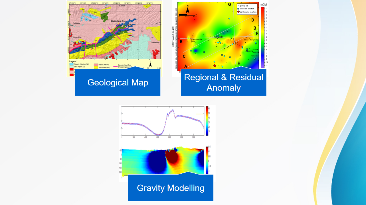
Understanding the subsurface system of the central part of West Bandung Regency (including Karst Area), Indonesia, is an important undertaking carried out by geological and geophysical investigations. This research aims to identify geological subsurface features, especially faults,that have an impact on geohazards in the area. To achieve this goal, deep analysis of geology, geomorphology, and geophysical data is conducted. The central part of West Bandung regency is crossed by the Cimandiri Fault, which is located east of the transitional zone between the frontal subduction of Java and the oblique subduction of Sumatra. The preliminary result shows that the active fault has an impact on geohazards (earthquakes and landslides) in the area. Gravity reduction, regional and residual separation, as well as forward modeling with the Pluoff Equation, are all parts of the examination of the gravity data. A second-order polynomial trend surface was subtracted from the entire Bouguer gravity grid to create the residual gravity anomaly map. The amplitudes of the anomalies range from −12 to 8 mGal. The density distribution from the inverse calculation using 4 horizontal line sections (AB, CD, EF, and GH) was set up in the range of −0.3 to +0.3 g/cc. Geological surface markers for the model can be correlated with the information from the Cianjur Sheet geological map. Regional structure is also interpreted in the model to show the main structure of the reverse fault in the study area.
HIGHLIGHTS
- The gravity method using density properties can provide good information about the subsurface karst system
- Modeling data gravity contributes to an understanding of geological subsurface interpretation
- Identifying geological subsurface features, especially faults that cause earthquakes and trigger landslides, is part of geohazard mitigation
GRAPHICAL ABSTRACT
Downloads
References
N Rohaendi, E Sukiyah, D Muslim and A Cipta. Geo-tourism land suitability analysis of citatah karst area in Bandung basin using spatial multi criteria evaluation (SMCE). Geo J. Tourism Geosites 2021; 39, 1346-53.
N Rohaendi, E Sukiyah, D Muslim and A Cipta. A sustainable development strategy for mining industries in citatah karst area in Bandung basin. IOP Conf. Ser. Earth Environ. Sci. 2021; 882, 012074.
AC Waltham and PD Fookes. Engineering classification of karst ground conditions. Q. J. Eng. Geol. Hydrogeology 2003; 36, 101-18.
Z Zakaria. The eastern cimandiri fault and its implications for landslides in citatah, West Bandung. Indonesian J. Geol. 2005; 20, 41-50.
B Yunianto. Study on the use of the Citatah karst area for the mining industry in West Bandung. J. Ind. Miner. 2009; 5, 15-27.
N Darjdi, T Villemin and JP Rampnoux. Paleo stresses and strike-slip movement: The Cimandiri fault zone, West Java, Indonesia. J. Southeast Asian Earth Sci. 1994; 9, 3-11.
L Handayani, M Maryati, K Kamtono, MM Mukti and Y Sudrajat. Audio-magnetotelluric modeling of Cimandiri fault zone at Cibeber, Cianjur, Indonesian. Indonesian J. Geosci. 2017; 4, 39-47.
GI Marliyani, JR Arrowsmith and KX Whipple. Characterization of slow slip rate faults in humid areas: Cimandiri fault zone, Indonesia. J. Geophys. Res. Earth Surf. 2016; 121, 2287-308.
Demnas Website, Available at: https://tanahair.indonesia.go.id/demnas/#/, accessed 18 November 2021.
A Hoffman-Rothe, O Ritter and V Haak. Magnetotelluric and geomagnetic modelling reveals zones of very high electrical conductivity in the upper crust of Central Java. Phys. Earth Planet. In. 2001; 124, 131-51.
AH Satyana. Central Java, Indonesia - a “Terra incognita” in petroleum exploration: New considerations on the tectonic evolution and petroleum implications. In: Proceedings, Indonesian Petroleum Association Thirty-First Annual Convention and Exhibition, Sulawesi, Indonesia. 2007.
R Hall. Late Jurassic-Cenozoic reconstructions of the Indonesian Region and the Indian Ocean. Tectonophysics 2012; 570-571, 1-41.
TO Simandjuntak and AJ Barber. Contrasting tectonic styles in the neogene orogenic belts of Indonesia. Geol. Soc. Spec. Publ. 1996; 106, 185-201.
PusGen. Indonesia Earthquake source & hazard Map 2017. Ministry Of Public Works and Public Housing, Jakarta, Indonesia, 2017.
S Supartoyo, S Surono and ET Putranto. Catalog of destructive Earthquakes in Indonesia years 1612 - 2014, Volcanology survey Indonesia. Geological Agency, Central Java, Indonesia, 2014.
M Martodjojo and P Pulunggono. Paleogen - neogen Tectonic changes are the most important events in Java Island. In: Proceedings of the Geology and Geotectonic, Sulawesi, Indonesia. 1994, p. 37-50.
R Hall and D Blundell. Tectonic evolution of Southeast Asia. Geol. Soc. Spec. Publ. 1996; 106, 185-201.
P Supendi, AD Nugraha, NT Puspito, S Widiyantoro and D Daryono. Identification of active faults in West Java, Indonesia, based on earthquake hypocenter determination, relocation, and focal mechanism analysis. Geosci. Lett. 2018; 5, 31.
HZ Abidin, H Andreas, T Kato, T Ito, I Meilano, F Kimata, DH Natawidjaya and H Harjono. Crustal deformation studies in Java (Indonesia) using gps. J. Earthquake Tsunami 2009; 3, 77-88.
F Febriani, L Handayani, A Setyani, T Anggono, S Syuhada and B Soedjatmiko. Dimensionality and regional strike analyses of the cibeber segment, Cimandiri fault zone, West Java, Indonesia. J. Phys. Conf. Series 2018; 985, 012016.
MZ Panatagama, F Febriani, S Maryanto and L Handayani. The phase tensor analysis of the Nyalindung segment, Cimandiri fault zone, West Java, Indonesia. J. Phys. Conf. Series 2019; 1191, 012011.
RD Kartiko, B Brahmantyo and IA Sadisun. Slope and lithological controls on landslide distribution in West Java, Indonesia. In: Proceedings of the International Symposium on Geotechnical Hazards: Prevention, Mitigation and Engineering Response, West Java, Indonesia. 2006, p. 177-84.
M Hermana, M Genisa, LA Lubis and CW Sum. Identification of active faults in landslide-prone regions using ground-penetrating radar: A case study from Bandung, Indonesia. Earth Crust 2019; 4, 1-12.
JB Winarto, E Sukiyah, AD Haryanto and I Haryanto. Sub surface active fault identification on quaternary and tertiary rocks using geoelectric method in cilaki drainage basin, Southern Part of West Java, Indonesia. Int. J. Adv. Sci. Eng. Inform. Tech. 2019; 9, 5.
D Abdurrahman, D Santoso, WGA Kadir, D Dahrin, S Setianingsih and S Alawiyah. Using gravity fault identification data in Bandung Basin. AIP Conf. Proc. 2018; 1987, 020062.
N Rohaendi, R Robiana, E Sukiyah, D Muslim and A Cipta. Seismic hazard zonation in gedebage future development in Bandung city using HVSR inversion. Int. J. Adv. Sci. Eng. Inform. Tech. 2021; 11, 947-54.
WM Telford, LP Geldart, RE Sherif and DA Keys. Applied geophysics. Cambridge University Press, Cambridge, 1990.
M Longman. Formulas for computing the tidal accelerations due to the Moon and the Sun. J. Geophys. Res. 1959; 64, 2351-5.
RJ Blakely. Potential theory in gravity and magnetic applications. Cambridge University Press, Cambridge, 1996.
EJ Wahyudi, D Santoso, WGA Kadir, and W Aji. Bouguer anomaly comparison using elevation data measured with hand-held device and geodetic gps in blora and pandan mountain. IOP Conf. Ser. Earth Environ. Sci. 2019; 318, 012031.
EJ Wahyudi, A Laesanpura, and D Sukmayadi. Gravity observation of field camp geophysics in karangsambung using data acquisition 2005 - 2019. AIP Conf. Proc. 2021; 873, 012049.
D Pluoff. Gravity and magnetic fields of polygonal prisms and application to magnetic terrain corrections. Geophysics 1976; 41, 727-41.
CA Mendonca and JBC Silva. Interpolation of potential-field data by equivalent layer and minimum curvature: A comparative analysis. Geophysics 1995; 60, 399-407.
D Sarah, E Soebowo and NA Satriyo. Review of the land subsidence hazard in Pekalongan Delta, Central Java: Insights from the subsurface. Rudarsko Geološko Naftni Zbornik 2021; 55, 163-76.
S Setianingsih, E Rustan, AKW Gunawan, D Santoso, AC Idham and S Alawiyah. Gravity gradient technique to identify fracture zones in palu koro strike-slip fault. Procedia Environ. Sci. 2013; 17, 248-55.
S Sudjatmiko. Geologic Map of Cianjur Quadrangle Java, Scale 1:100.000 (Center, Bandung, (2nd: Geological Research and Development). Geological Research and Development, West Java, Indonesia, 1994.
Downloads
Published
How to Cite
Issue
Section
License
Copyright (c) 2023 Walailak University

This work is licensed under a Creative Commons Attribution-NonCommercial-NoDerivatives 4.0 International License.