
Performance of Sentinel-2A Remote Sensing System for Urban Area Mapping in Malaysia via Pixel-Based and OBIA Methods
DOI:
https://doi.org/10.48048/tis.2021.38Keywords:
Sentinel-2, Landsat-8, Urban mapping, Image classification, Object-based classificationAbstract
Sentinel-2A remote sensing satellite system was recently launched, providing free global remote sensing data similar to Landsat systems. Although the mission enables the acquisition of 10 m spatial resolution global data, the assessment of Sentinel-2A data performance for mapping in Malaysia is still limited. This study aimed to investigate and assess the capability of Sentinel-2A imagery in mapping urban areas in Malaysia by comparing its performance against the established Landsat-8 data as well as the fusion datasets from combining Landsat-8 and Sentinel-2A datasets and using Wavelet transform (WT), Brovey transform (BT) and principal component analysis. Pixel-based and object-based image analysis (OBIA) classification approaches combined with support vector machine (SVM) and decision tree (DT) algorithms were utilized in this assessment, and the accuracy generated was analysed. The Sentinel-2A data provided superior urban mapping output over the use of Landsat-8 alone, and the fusion datasets do not yield advantages for single-scene urban mapping. The highest overall accuracy (OA) for pixel-based classification of Sentinel-2A images is 84.77 % by SVM, followed by 65.27 % using DT. BT produced the highest OA for the fusion images of 78.40 % with SVM and 52.21 % with DT. For the object-based classification of Sentinel-2A images, the highest OA is 71.33 % by SVM, followed by 76.38 % using DT. Similarly, the highest OA of fusion images is obtained by BT of 50.35 % with SVM, followed by 65.66 % with DT. From the analysis, the use of SVM pixel-based classification for medium spatial resolution Sentinel-2A data is effective for urban mapping in Malaysia and useful for future long-term mapping applications.
HIGHLIGHTS
- An accurate mapping of urban land is still challenging and requires high image quality of spectral and spatial aspects to identify features
- Single and fusion image analysis conducted in order to investigate and assess the most performing interpretation result by grouping out the features classes
- Statistical performance and image classification comparison is relevant to prove the most effective result among the images
GRAPHICAL ABSTRACT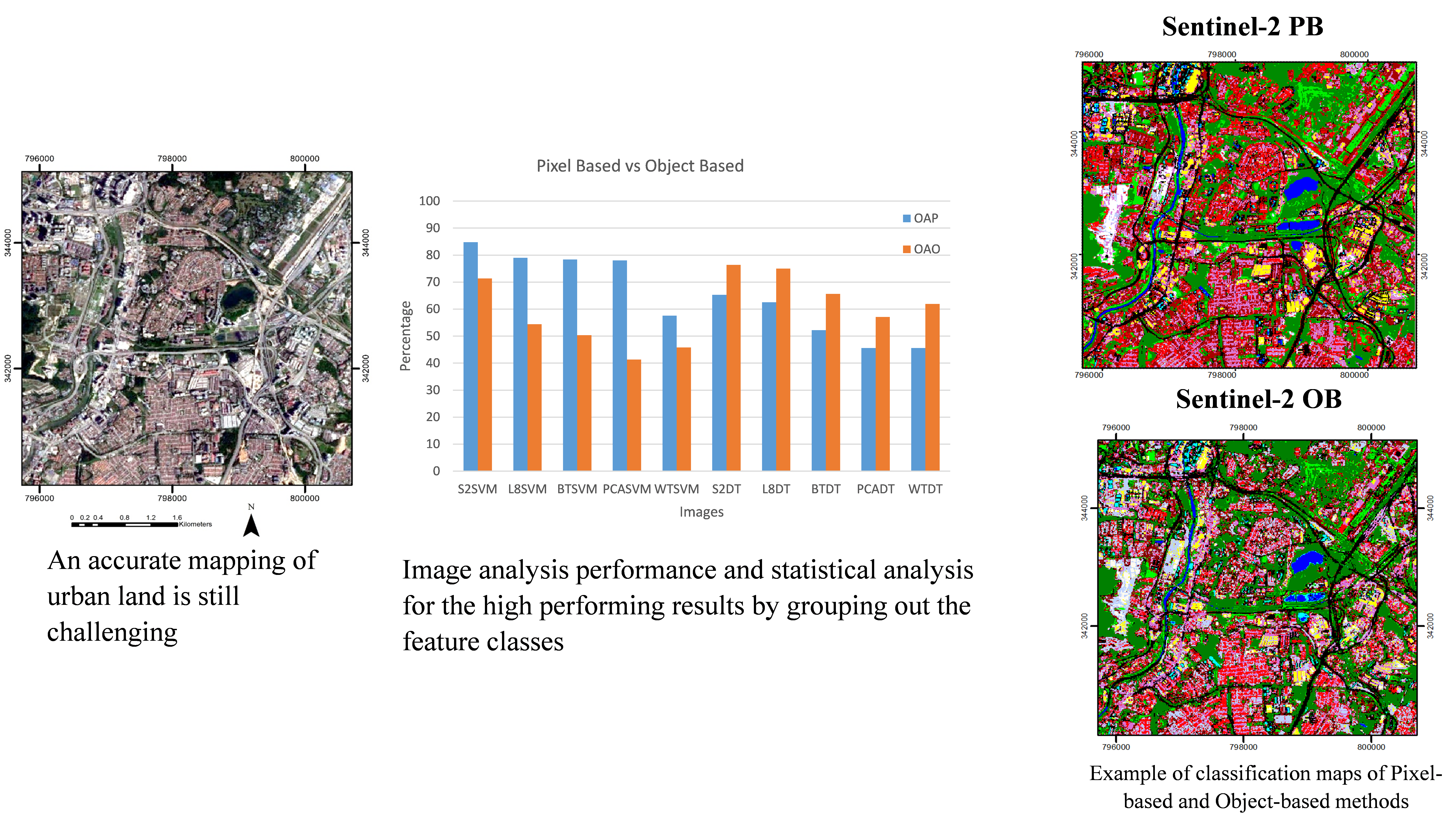
Downloads
References
F Pacifici, M Chini and WJ Emery. A neural network approach using multi-scale textural metrics from very high-resolution panchromatic imagery for urban land-use classification. Rem. Sens. Environ. 2009; 113, 1276-92.
HZM Shafri, E Taherzadeh, S Mansor and R Ashurov. Hyperspectral remote sensing of urban areas: An overview of techniques and applications. Res. J. Appl. Sci. Eng. Tech. 2012; 4, 1557-65.
K Jia, X Wei, X Gu, Y Yao, X Xie and B Li. Land cover classification using Landsat 8 Operational Land Imager data in Beijing, China. Geocarto Int. 2014; 29, 941-51.
MN Tuanmu and W Jetz. A global 1-km consensus land-cover product for biodiversity and ecosystem modelling. Glob. Ecol. Biogeogr. 2014; 23, 1031-45.
S Gadal and W Ouerghemmi. Morpho-spectral recognition of dense urban objects by hyperspectral imagery. Int. Arch. Photogram. Rem. Sens. Spatial Inf. Sci. 2015; XL-3/W3, 433-8
G Suresh, R Gehrke, T Wiatr and M Hovenbitzer. Synthetic aperture radar (SAR) based classifiers for land applications in Germany. Int. Arch. Photogram. Rem. Sens. Spatial Inf. Sci. 2016; XLI-B1, 1187-93.
XY Wang, YG Guo, J He and LT Du. Fusion of HJ1B and ALOS PALSAR data for land cover classification using machine learning methods. Int. J. Appl. Earth Observat. Geoinform. 2016; 52, 192-203.
M Pesaresi, C Corbane, A Julea, AJ Florczyk, V Syrris and P Soille. Assessment of the added-value of Sentinel-2 for detecting built-up areas. Rem. Sens. 2016; 8, 299.
J Haas and Y Ban. Sentinel-1A SAR and Sentinel-2A MSI data fusion for urban ecosystem service mapping. Rem. Sens. Appl. Soc. Environ. 2017; 8, 41-53.
J Radoux, G Chomé, DC Jacques, F Waldner, N Bellemans, N Matton, C Lamarche, R D’Andrimont and P Defourny. Sentinel-2’s potential for sub-pixel landscape feature detection. Rem. Sens. 2016; 8, 488.
N Clerici, CAV Calderón and JM Posada. Fusion of sentinel-1A and sentinel-2A data for land cover mapping: A case study in the lower Magdalena region, Colombia. J. Map. 2017; 13, 718-26.
DC Duro, SE Franklin and MG Dubé. A comparison of pixel-based and object-based image analysis with selected machine learning algorithms for the classification of agricultural landscapes using SPOT-5 HRG imagery. Rem. Sens. Environ. 2012; 118, 259-72.
SW Myint, P Gober, A Brazel, S Grossman-Clarke and Q Weng. Per-pixel vs. object-based classification of urban land cover extraction using high spatial resolution imagery. Rem. Sens. Environ. 2011; 115, 1145-61.
MBA Gibril, SA Bakar, K Yao, MO Idrees and B Pradhan. Fusion of RADARSAT-2 and multispectral optical remote sensing data for LULC extraction in a tropical agricultural area. Geocarto Int. 2017; 32, 735-48.
F Pirotti, F Sunar and M Piragnolo. Benchmark of machine learning methods for classification of a Sentinel-2 image. Int. Arch. Photogram. Rem. Sens. Spatial Inf. Sci. 2016; XLI-B7, 335-40
RH Topaloǧlu, E Sertel and N Musaoǧlu. Assessment of classification accuracies of Sentinel-2 and Landsat-8 data for land cover/use mapping. Int. Arch. Photogram. Rem. Sens. Spatial Inf. Sci. 2016; XLI-B8, 1055-9.
D Liu and F Xia. Assessing object-based classification: Advantages and limitations. Rem. Sens. Lett. 2010; 1, 187-94.
Q Wang, GA Blackburn, AO Onojeghuo, J Dash, L Zhou, Y Zhang and PM Atkinson. Fusion of Landsat 8 OLI and Sentinel-2 MSI data. IEEE Trans. Geosci. Rem. Sens. 2017; 5, 3885-99.
M Drusch, UD Bello, S Carlier, O Colin, V Fernandez, F Gascon, B Hoersch, C Isola, P Laberinti, P Martimort, A Meygret, F Spoto, O Sy, F Marchese and P Bargellini. Sentinel-2: ESA’s optical high-resolution mission for GMES operational services. Rem. Sens. Environ. 2012; 120, 25-36.
O Hagolle, S Sylvander, M Huc, M Claverie, D Clesse, C Dechoz, V Lonjou and V Poulain. SPOT-4 (take 5): Simulation of sentinel-2 time series on 45 large sites. Rem. Sens. 2015; 7, 12242-64.
AD Vaiopoulos and K Karantzalos. Pansharpening on the narrow VNIR and SWIR spectral bands of Sentinel-2. Int. Arch. Photogram. Rem. Sens. Spatial Inf. Sci. 2016; XLI-B7, 723-30.
CK Singh. Geospatial applications for natural resources management. CRC Press, Florida, 2018, p. 1-9.
J Zhang, C Pohl and JV Genderen. Remote sensing image fusion: A practical guide. CRC Press, Florida, 2017, p. 92-3.
T Kuchma. Combined use of SAR and optical satellite images for landscape diversity assessment. In: Proceedings of the Living Planet Symposium, Prague, Czech Republic. 2016.
A Abdulle, AA Tan, B Pradhan and S Abdullahi. Temporal assessment on land use land cover of Somalia after the effect of the civil war using remote sensing. In: Proceedings of the 8th IGRSM International Conference and Exhibition on Geospatial & Remote Sensing, Kuala Lumpur, Malaysia. 2016.
S Moustakidis, G Mallinis, N Koutsias, JB Theocharis and V Petridis. SVM-based fuzzy decision trees for classification of high spatial resolution remote sensing images. IEEE Trans. Geosci. Rem. Sens. 2012; 50, 149-69.
J Al-doski, SB Mansor and HZM Shafri. Image classification in remote sensing. J. Environ. Earth Sci. 2013; 3, 141-7.
JR Jensen. Introductory digital image processing: A remote sensing perspective. 3rd ed. Pearson Prentice Hall, New Jersey, 2015, p. 505-12.
W Min. A Multiresolution Remotely Sensed Image Segmentation Method Combining Rainfalling Watershed Algorithm and Fast Region Merging. Int. Arch. Photogram. Rem. Sens. Spatial Inf. Sci. 2008; XXXVII, 1213-8.

Downloads
Published
How to Cite
Issue
Section
License

This work is licensed under a Creative Commons Attribution-NonCommercial-NoDerivatives 4.0 International License.