
The Effect of Erosion Control Practices on the Vulnerability of Soil Degradation in Oued EL Malleh Catchment using the USLE Model Integrated into GIS, Morocco
DOI:
https://doi.org/10.48048/tis.2022.2059Keywords:
Soil erosion, USLE, Remote sensing, Morocco, Soil degradationAbstract
Water erosion is a major problem in semi-arid region where decreases the dam reservoir design capacity, agricultural yield productivity, and increases other environmental impacts. This phenomenon is widely predominant in Morocco, particularly in the Oued El Malleh watershed in the Casablanca Settat region. Most soil erosion happens gradually which makes it challenging to notice. Hence, the monitoring of soil degradation under a modelling-based, such as Geographic Information System (GIS) can help the decision-makers to quantify the eroded soil and choose the best mitigation measures. Many erosion control practices have been implemented in The Oued El Malleh watershed in 2008, which covers a surface area of 3127 km2. Even though, the soil erosion still dramatic in the region. To date, no one has attempted to work on the impact of the soil conservation factor at the level of the Oued El Malleh watershed, as well as monitoring the sustainability and effectiveness of the water erosion control practices already implemented. Therefore, periodic monitoring and evaluating soil degradation is imposed. To achieve this purpose, we used the Universal Soil Loss Equation (USLE) to spatially assess water erosion in the study area, to find out the most vulnerable area to erosion, to notice the efficiency of the actual erosion control practices and elaborate on new mitigation measures. The results of this study have been shown that the rate of soil loss in the Oued El Malleh, including the actual control erosion interventions, varies from 0 to 90 t. ha-1.year-1; with an average erosion rate of 0.65 t. ha-1.year-1. The study area characterized by a moderate to severe slopes, in some area, the Length and Steepness Factor LS exceeds 90 %. For this reason, we have been elaborated new soil loss map, including soil conservation measures according to the slope. The soil loss rate; following this approach; varies from 0 to 64 t.ha-1.year-1. Furthermore, the followed approach could be valuable for assessing the soil loss in similar area.
HIGHLIGHTS
- Casablanca-Settat agricultural lands become progressively infertile and depleted soils
- Soil degradation by water erosion is a tidal problem in the Oued El Malleh watershed
- Soil loss was estimated at a watershed level using the USLE model and ArcGIS tool
- The soil loss rate is estimated to be 0.65 t. ha-1.year-1, and the average sedimentary yield is found at 8.27 t. ha-1.year-1
- Sustainable land management can limit soil degradation
GRAPHICAL ABSTRACT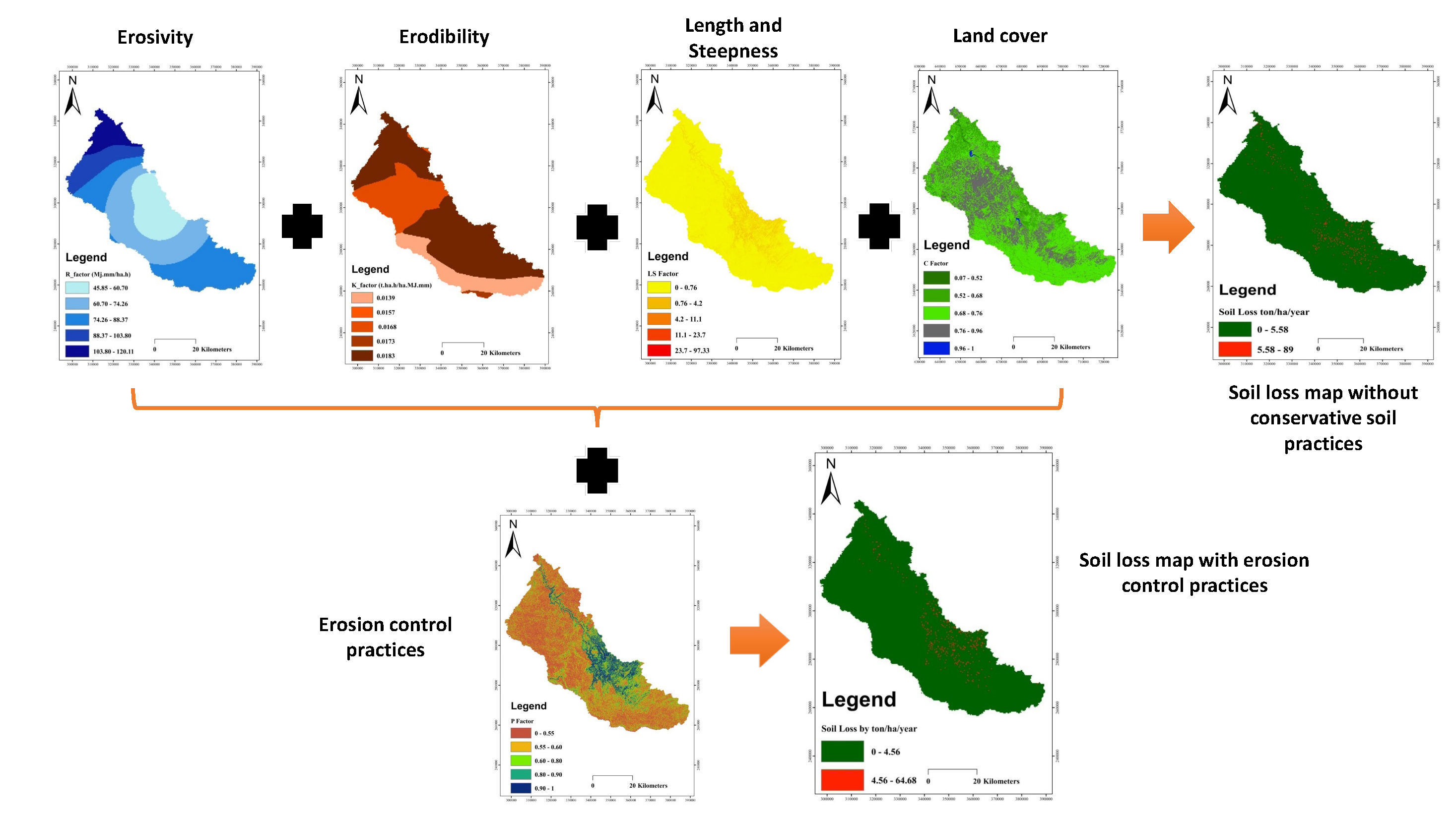
Downloads
References
R Lal. Soil erosion impact on agronomic productivity and environment quality. Crit. Rev. Plant Sci. 1998; 17, 319-464.
A Boudhar, B Duchemin, L Hanich, A Chaponnière, P Maisongrande, G Boulet, J Stitou and A Chehboun. Analyse de la dynamique des surfaces enneigées du Haut Atlas marocain à partir des données SPOT-VEGETATION. Sécheresse 2007; 18, 278-88.
K Vezina, F Bonn and PV Cu. Agricultural land-use patterns and soil erosion vulnerability of watershed units in Vietnam’s northern highlands’. Landsc. Ecol. 2006; 21, 1311-25.
R Parveen and U Kumar. Integrated approach of Universal Soil Loss Equation (USLE) and Geographical Information System (GIS) for soil loss risk assessment in Upper South Koel Basin, Jharkhand. 2012; 4, 588-96.
TA Adongo, JX Kugbe and VD Gbedzi. Siltation of the reservoir of Vea irrigation dam in the Bongo district of the Upper East Region, Ghana. 2014; 4, 1-7.
WH Wischmeier and DD Smith. Predicting rainfall erosion losses: A guide to conservation planning. Department of Agriculture, Science and Education Administration, 1978.
KG Renard, GR Foster, GA Weesies, DK McCool and DC Yoder. Predicting Soil Erosion by Water: A Guide to conservation planning with the Revised Universal Soil Loss Equation (RUSLE). United State Department of Agriculture, Washington DC, 1997.
KP Bhandari and R Darnsawasdi. Application of remote sensing and participatory soil erosion assessment approach for soil erosion mapping in a watershed. Walailak J. Sci. Tech. 2015; 12, 689-702.
AE Bilali, T Abdeslam, BE Idrissi, Y Brouziyne and N Mazigh. Comparison of a data-based model and a soil erosion model coupled with multiple linear regression for the prediction of reservoir sedimentation in a semi-arid environment. Euro-Mediterr. J. Environ. Integr. 2020; 5, 64.
C Alewell, P Borrelli, K Meusburger and P Panagos. Using the USLE: Chances, challenges and limitations of soil erosion modelling. Int. Soil Water Conserv. Res. 2019; 7, 203-25.
N Shivhare, PKS Dikshit and SB Dwivedi. A comparison of SWAT model calibration techniques for hydrological modeling in the Ganga River Watershed. Engineering. 2018; 4, 643-52.
VC Piscoya, WPD Souza, JRB Cantalice, MC Filho, RCPD Melo and RNDA Filho. WEPP Model for rill erosion estimation in a Brazilian Semiarid Watershed. Rev. Caatinga. 2020; 33, 835-43.
N Baggaley and J Potts. Sensitivity of the PESERA soil erosion model to terrain and soil inputs. Geoderma Reg. 2017; 11, 104-12.
Y Bouslihim, A Rochdi and NEA Paaza. Combining SWAT model and regionalization approach to estimate soil erosion under limited data availability conditions. Eurasian Soil Sci. 2020; 53, 1280-92.
CJLM Falcão, SMDA Duarte and ADS Veloso. Estimating potential soil sheet Erosion in a Brazilian semiarid county using USLE, GIS, and remote sensing data. Environ. Monit. Assess. 2020; 192, 47.
J Wu and J Lu. Spatial scale effects of landscape metrics on stream water quality and their seasonal changes. Water Res. 2021; 191, 116811.
T Rodrigues, E Alcântara, L Rotta, N Bernardo and F Watanabe. An investigation into the relationship between light absorption budget and trophic status in inland waters. Ecol. Indic. 2020; 115, 106410.
JJ Chevalier, J Pouliot, K Thomson and MR Boussema. Systèmes d’aide à la planification pour la conservation des eaux et des sols (Tunisie). Systèmes d’information géographique utilisant les données de télédétection. Actes du Colloque Scientifique International, Hammamet, Tunisie, 1994.
AA Fora. 1995, Spatial modeling of water erosion in a Moroccan rock watershed: Validation of the geomatic approach by sedimentology, radioactive tracers and magnetic susceptibility of sediments. Ph. D. Dissertation. Université de Sherbrooke, Sherbrooke, Canada.
A Lahlou. Specific degradation of watershed in Morocco. Report n° 1000, Ministry of Equipment and National Promotion, water direction, exploitation division. Water Management Service, Rabat, 1977.
O Mhirit and F Benchekroun. Les écosystèmes forestiers et périforestiers: Situation, enjeux et perspectives pour 2025. Rapp. Général. 2006; 50, 395-468.
M Tahri, A Merzouk, HF Lamb and RW Maxted. Etude de l’erosion hydrique dans le plateau d’imelchil dans le Haut-Atlas central utilisation d’un S.I.G. d’érosion. GEO Observateur 1993; 3, 5160.
T Merzouki. Diagnostic de l’envasement des grands barrages marocains. Rev. Marocaine Génie Civ.1992; 38, 4650.
H Lahlaoi, H Rhinane, A Hilali, S Lahssini and L Khalile. Potential erosion risk calculation using remote sensing and GIS in Oued El Maleh Watershed, Morocco. J. Geogr. Inf. Syst. 2015; 7, 128.
K Abdelouafi, W Annouar, D Lahcen and E Samira. 2012, Quantification de l’érosion hydrique linéaire dans le bassin versant d’Oued El Malleh: Cas du micro bassin de Sidi Sbea. Mémoire de fin d’études, Faculté des Sciences et Techniques Marrakech, Marrakech, Maroc, p. 66.
AE Bilali, A Taleb and I Boutahri. Application of HEC-RAS and HEC-LifeSim models for flood risk assessment. J. Appl. Water Eng. Res. 2021; 9, 336-51.
WH Wischmeier and DD Smith. A universal soil-loss equation to guide conservation farm planning. Trans. 7th Int. Congr. Soil Sci. 1960; 1, 418-25, 1960.
O Cerdan. Guide méthodologique pour un zonage départemental de l’érosion des sols. Rapport n° 3: Synthèse et recommandations générales. Bureau de Recherches Géologiques et Minières, France, 2006.
HEH Hassan, L Charbel and L Touchart. Modélisation de l’érosion hydrique à l’échelle du bassin versant du Mhaydssé. Békaa-Liban. VertigO 2018; 18, 19804.
A Belasri and A Lakhouili. Estimation of soil erosion risk using the universal soil loss equation (USLE) and geo-information technology in Oued El Makhazine Watershed, Morocco. J. Geogr. Inf. Syst. 2016; 8, 98-107.
G Team. GeoNetwork opensource portal to spatial data and information, Available at: http://www.fao.org/geonetwork/srv/en/metadata.show?id=14116, accessed August, 2020.
TG Farr, PA Rosen, E Caro, R Crippen, R Duren, S Hensley, M Kobrick, M Paller, E Rodriguez, L Roth, D Seal, S Shaffer, J Shimada, J Umland, M Werner, M Oskin, D Burbank and D Alsdorf. The shuttle radar topography mission. Rev. Geophys. 2007; 45, RG2004.
G Boggs, C Devonport, K Evans and P Puig. GIS-based rapid assessment of erosion risk in a small catchment in the wet/dry tropics of Australia. Land Degrad. Dev. 2001; 12, 417-34.
CEP Cerri, JAM Demattě, MVR Ballester, LA Martinelli, RL Victoria and E Roose. GIS Erosion risk assessment of the Piracicaba River Basin, Southeastern Brazil. Mapp. Sci. Rem. Sens. 2001; 38, 157-71.
RA Shakesby, COA Coelho, S Schnabel, JJ Keizer, MA Clarke, JFL Contador, RPD Walsh, AJD Ferreira and SH Doerr. A ranking methodology for assessing relative erosion risk and its application to dehesas and montados in Spain and Portugal. Land Degrad. Dev. 2002; 13, 129-40.
R Kheir, A Shaban, MC Girard and M Khawlie. Impact des activités humaines sur l’érosion hydrique des sols dans la région côtière montagneuse du Liban. Sécheresse 2001; 12, 157-65.
HMJ Arnoldus. Methodology used to determine the maximum potential average annual soil loss due to sheet and rill erosion in Morocco. FAO Soils Bull. 1977; 34, 39-48
L Hui, C Xiaoling, KJ Lim, C Xiaobin and M Sagong. Assessment of soil erosion and sediment yield in Liao watershed, Jiangxi Province, China, Using USLE, GIS, and RS. J. Earth Sci. 2010; 21, 941-53.
JR Williams. The EPIC model. In: VP Singh (Ed.). Computer models of watershed hydrology. Water Resources Publications, Highlands Ranch, CO, 1995, p. 909-1000.
E Roose. Introduction à la gestion conservatoire de l’eau, de la biomasse, et de la fertilité des sols (GCES). FAO, Montpellier, France, 1999, p. 420.
N Hudson. Soil conservation. BT Batsford, London, 1973.
AW Zingg. Degree and length of land slope as it affects soil loss in run-off. Agr. Eng. 1940; 21, 5964.
E Payet, P Dumas and G Pennober. Modélisation de l’érosion hydrique des sols sur un bassin versant du sud-ouest de Madagascar, le Fiherenana. VertigO 2012; 11, 12591.
RB Kheir. 2002, Etude des risques d’érosion hydrique des sols par télédétection et SIG: Application à une région représentative du Liban. Ph. D. Dissertation. Institut national agronomique Paris Grignon, Paris, France.
MC Battany and ME Grismer. Rainfall runoff and erosion in Napa Valley vineyards: Effects of slope, cover and surface roughness. 2000; 14, 1289-304.
KD Reid, BP Wilcox, DD Breshears and L MacDonald. Runoff and erosion in a piiion-juniper woodland: Influence of vegetation patches. Soil Sci. Soc. Am. J. 63, 1869-79.
S Toumi, M Meddi, G Mahé and YT Brou. Cartographie de l’érosion dans le bassin versant de l’Oued Mina en Algérie par télédétection et SIG’, Hydrol. Sci. J. 2013; 58, 1542-58.
R Caloz and C Collet. Précis de télédétection - Volume 3: Traitements numériques d’images de télédétection. Presses de l'Université du Québec, Quebec, Canada, 2001.
JMVD Knijff, RJA Jones and L Montanarella. Soil erosion risk assessment in Europe. European Soil Bureau, Ispra, Italy, 2000.
MVD Knijff, RJA Jones and L Montanarella. ‘lao’, EUR19022. European Soil Bureau, Ispra, Italy, 1999.
A Laouina. ‘dri’. Publ FLSH University Mohammed V Agdal Rabat, Rabat, Morocco, 2007.
EH Driss and A Brahim. Quantification de l’erosion hydrique en utilisant le modèle rusle et déposition intégrée dans un sig. cas du bassin versant de l’oued isly (Maroc Oriental). Eur. Sci. J. 2018; 14, 373.
A Zouagui, M Sabir, M Naimi, M Chikhaoui and M Benmansour. Modelisation du risque d’érosion hydrique par l’équation universelle des pertes en terre dans le rif occidental: Cas du bassin versant de moulay bouchta (Maroc). Eur. Sci. J. 2018; 14, 524.
L Dhman, A Merzouk, M Sabir and I Fenjiro. Cartographie des pertes en terre dues à l’érosion hydrique par utilisation d’un système d’information géographique et des images satellites. Cas du bassin versant de Telata (Maroc). Atelier Trav. Sur Modélisation L’érosion Hydr. Par RUSLE. 1997, p. 52-65.
M Modeste, K Abdellatif, M Nadia and H Zhang. cartographie des risques de l’erosion hydrique par l’equation universelle revisee des pertes en sols, la teledetection et les sig dans le bassin versant de l’ourika (Haut Atlas, Maroc). Eur. Sci. J. 2016; 12, 277.
P Roy. Application of USLE in a GIS environment to estimate soil erosion in the Irga watershed, Jharkhand, India. Phys. Geogr. 2019; 40, 361-83.
C Lin, R Ma and B He. Identifying watershed regions sensitive to soil erosion and contributing to lake eutrophication - a case study in the Taihu Lake Basin (China). Int. J. Environ. Res. Publ. Health. 2015; 13, 77.
GJ Shin. 1999, The analysis of soil erosion analysis in watershed using GIS. Ph. D. Dissertation. Department of Civil Engineering, Gangwon National University. Chuncheon, South Korea.
B Bagio, I Bertol, NH Wolschick, D Schneiders and MADND Santos. Water erosion in different slope lengths on bare soil. Rev. Bras. Ciênc. Solo. 2017; 41, e0160132.
V Bagarello, V Ferro and D Flanagan. Predicting plot soil loss by empirical and process-oriented approaches. A review. J. Agr. Eng. 2018; 49, 1-18.
M Manaouch, A Zouagui and I Fenjiro. A review of soil erosion modeling by R/USLE in Morocco: Achievements and limits. E3S Web Conf. 2021; 234, 00067.
Downloads
Published
How to Cite
Issue
Section
License

This work is licensed under a Creative Commons Attribution-NonCommercial-NoDerivatives 4.0 International License.